You are here: Home > Network List > TA - USArray Transportable Network (new EarthScope stations) Stations List
> Station M18K Stony River, AK, USA > Earthquake Result Viewer
M18K Stony River, AK, USA - Earthquake Result Viewer
| Earthquake location: |
Central California |
| Earthquake latitude/longitude: |
35.7/-117.5 |
| Earthquake time(UTC): |
2019/07/04 (185) 17:33:49 GMT |
| Earthquake Depth: |
11 km |
| Earthquake Magnitude: |
6.4 mw |
| Earthquake Catalog/Contributor: |
NEIC PDE/ci |
|
| Network: |
TA USArray Transportable Network (new EarthScope stations) |
| Station: |
M18K Stony River, AK, USA |
| Lat/Lon: |
61.49 N/155.82 W |
| Elevation: |
289 m |
|
| Distance: |
35.3 deg |
| Az: |
329.015 deg |
| Baz: |
119.154 deg |
| Ray Param: |
0.077295214 |
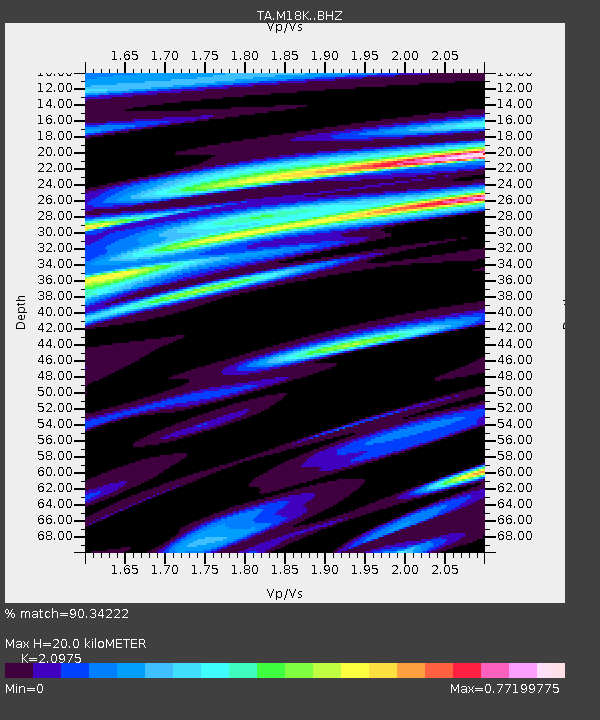
| Estimated Moho Depth: |
20.0 km |
| Estimated Crust Vp/Vs: |
2.10 |
| Assumed Crust Vp: |
6.566 km/s |
| Estimated Crust Vs: |
3.13 km/s |
| Estimated Crust Poisson's Ratio: |
0.35 |
|
| Radial Match: |
90.34222 % |
| Radial Bump: |
346 |
| Transverse Match: |
73.473755 % |
| Transverse Bump: |
400 |
| SOD ConfigId: |
19053131 |
| Insert Time: |
2019-07-18 17:38:32.430 +0000 |
| GWidth: |
2.5 |
| Max Bumps: |
400 |
| Tol: |
0.001 |
|

Signal To Noise
| Channel | StoN | STA | LTA |
| TA:M18K: :BHZ:20190704T17:40:13.200004Z | 2.2862635 | 1.8772555E-7 | 8.2110205E-8 |
| TA:M18K: :BHN:20190704T17:40:13.200004Z | 1.0693192 | 6.1774514E-8 | 5.776995E-8 |
| TA:M18K: :BHE:20190704T17:40:13.200004Z | 2.4778259 | 1.2700681E-7 | 5.125736E-8 |
| Arrivals |
| Ps | 3.6 SECOND |
| PpPs | 8.8 SECOND |
| PsPs/PpSs | 12 SECOND |


