You are here: Home > Network List > TA - USArray Transportable Network (new EarthScope stations) Stations List
> Station O07A Toulon, NV, USA > Earthquake Result Viewer
O07A Toulon, NV, USA - Earthquake Result Viewer
| Earthquake location: |
Kuril Islands |
| Earthquake latitude/longitude: |
45.8/150.1 |
| Earthquake time(UTC): |
2007/09/03 (246) 16:14:53 GMT |
| Earthquake Depth: |
94 km |
| Earthquake Magnitude: |
6.3 MB, 6.2 MW, 6.2 ME |
| Earthquake Catalog/Contributor: |
WHDF/NEIC |
|
| Network: |
TA USArray Transportable Network (new EarthScope stations) |
| Station: |
O07A Toulon, NV, USA |
| Lat/Lon: |
40.16 N/118.88 W |
| Elevation: |
1203 m |
|
| Distance: |
63.3 deg |
| Az: |
59.061 deg |
| Baz: |
308.514 deg |
| Ray Param: |
0.0594195 |
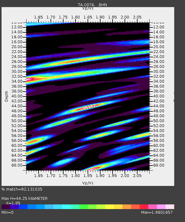
| Estimated Moho Depth: |
44.25 km |
| Estimated Crust Vp/Vs: |
1.85 |
| Assumed Crust Vp: |
6.276 km/s |
| Estimated Crust Vs: |
3.392 km/s |
| Estimated Crust Poisson's Ratio: |
0.29 |
|
| Radial Match: |
92.131035 % |
| Radial Bump: |
400 |
| Transverse Match: |
87.02017 % |
| Transverse Bump: |
400 |
| SOD ConfigId: |
2564 |
| Insert Time: |
2010-03-07 01:05:45.833 +0000 |
| GWidth: |
2.5 |
| Max Bumps: |
400 |
| Tol: |
0.001 |
|

Signal To Noise
| Channel | StoN | STA | LTA |
| TA:O07A: :BHN:20070903T16:24:41.700005Z | 10.002033 | 1.0420745E-6 | 1.04186256E-7 |
| TA:O07A: :BHE:20070903T16:24:41.700005Z | 15.226141 | 1.5038822E-6 | 9.876975E-8 |
| TA:O07A: :BHZ:20070903T16:24:41.700005Z | 41.20206 | 3.111004E-6 | 7.550603E-8 |
| Arrivals |
| Ps | 6.2 SECOND |
| PpPs | 19 SECOND |
| PsPs/PpSs | 26 SECOND |


