You are here: Home > Network List > PE - Penn State Network Stations List
> Station PAMP Mt. Pisgah State Park, Troy, PA > Earthquake Result Viewer
PAMP Mt. Pisgah State Park, Troy, PA - Earthquake Result Viewer
| Earthquake location: |
Central California |
| Earthquake latitude/longitude: |
35.6/-117.6 |
| Earthquake time(UTC): |
2019/07/04 (185) 17:35:01 GMT |
| Earthquake Depth: |
4.6 km |
| Earthquake Magnitude: |
4.5 Mlr |
| Earthquake Catalog/Contributor: |
NEIC PDE/ci |
|
| Network: |
PE Penn State Network |
| Station: |
PAMP Mt. Pisgah State Park, Troy, PA |
| Lat/Lon: |
41.81 N/76.67 W |
| Elevation: |
348 m |
|
| Distance: |
32.3 deg |
| Az: |
66.477 deg |
| Baz: |
272.671 deg |
| Ray Param: |
0.07873549 |
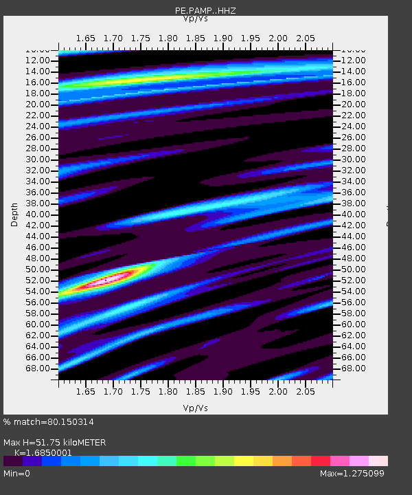
| Estimated Moho Depth: |
51.75 km |
| Estimated Crust Vp/Vs: |
1.69 |
| Assumed Crust Vp: |
6.121 km/s |
| Estimated Crust Vs: |
3.632 km/s |
| Estimated Crust Poisson's Ratio: |
0.23 |
|
| Radial Match: |
80.150314 % |
| Radial Bump: |
388 |
| Transverse Match: |
60.9303 % |
| Transverse Bump: |
400 |
| SOD ConfigId: |
19053131 |
| Insert Time: |
2019-07-18 17:41:48.503 +0000 |
| GWidth: |
2.5 |
| Max Bumps: |
400 |
| Tol: |
0.001 |
|

Signal To Noise
| Channel | StoN | STA | LTA |
| PE:PAMP: :HHZ:20190704T17:41:00.445004Z | 1.8756902 | 8.4885244E-7 | 4.525547E-7 |
| PE:PAMP: :HHN:20190704T17:41:00.445004Z | 1.222527 | 2.23277E-7 | 1.8263565E-7 |
| PE:PAMP: :HHE:20190704T17:41:00.445004Z | 1.9139704 | 7.940829E-7 | 4.1488775E-7 |
| Arrivals |
| Ps | 6.2 SECOND |
| PpPs | 21 SECOND |
| PsPs/PpSs | 27 SECOND |


