You are here: Home > Network List > TA - USArray Transportable Network (new EarthScope stations) Stations List
> Station I30M Mount Dempster, Yukon, CAN > Earthquake Result Viewer
I30M Mount Dempster, Yukon, CAN - Earthquake Result Viewer
| Earthquake location: |
Central California |
| Earthquake latitude/longitude: |
35.6/-117.6 |
| Earthquake time(UTC): |
2019/07/04 (185) 17:35:01 GMT |
| Earthquake Depth: |
4.6 km |
| Earthquake Magnitude: |
4.5 Mlr |
| Earthquake Catalog/Contributor: |
NEIC PDE/ci |
|
| Network: |
TA USArray Transportable Network (new EarthScope stations) |
| Station: |
I30M Mount Dempster, Yukon, CAN |
| Lat/Lon: |
65.22 N/136.38 W |
| Elevation: |
1399 m |
|
| Distance: |
31.7 deg |
| Az: |
345.003 deg |
| Baz: |
149.991 deg |
| Ray Param: |
0.078987025 |
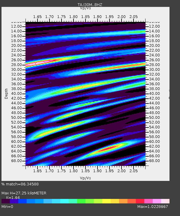
| Estimated Moho Depth: |
27.25 km |
| Estimated Crust Vp/Vs: |
1.64 |
| Assumed Crust Vp: |
6.566 km/s |
| Estimated Crust Vs: |
4.004 km/s |
| Estimated Crust Poisson's Ratio: |
0.20 |
|
| Radial Match: |
86.34588 % |
| Radial Bump: |
400 |
| Transverse Match: |
60.960983 % |
| Transverse Bump: |
400 |
| SOD ConfigId: |
19053131 |
| Insert Time: |
2019-07-18 17:42:18.512 +0000 |
| GWidth: |
2.5 |
| Max Bumps: |
400 |
| Tol: |
0.001 |
|
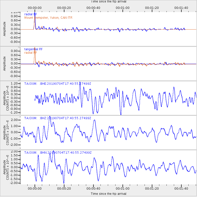
Signal To Noise
| Channel | StoN | STA | LTA |
| TA:I30M: :BHZ:20190704T17:40:55.27499Z | 2.4085674 | 1.0340718E-6 | 4.2933064E-7 |
| TA:I30M: :BHN:20190704T17:40:55.27499Z | 3.5027637 | 1.1133967E-6 | 3.1786234E-7 |
| TA:I30M: :BHE:20190704T17:40:55.27499Z | 2.656058 | 6.4873245E-7 | 2.4424634E-7 |
| Arrivals |
| Ps | 2.9 SECOND |
| PpPs | 10 SECOND |
| PsPs/PpSs | 13 SECOND |


