You are here: Home > Network List > TA - USArray Transportable Network (new EarthScope stations) Stations List
> Station O07A Toulon, NV, USA > Earthquake Result Viewer
O07A Toulon, NV, USA - Earthquake Result Viewer
| Earthquake location: |
Sea Of Japan |
| Earthquake latitude/longitude: |
36.8/134.9 |
| Earthquake time(UTC): |
2007/07/16 (197) 14:17:37 GMT |
| Earthquake Depth: |
350 km |
| Earthquake Magnitude: |
6.2 MB, 6.8 MW, 6.8 MW |
| Earthquake Catalog/Contributor: |
WHDF/NEIC |
|
| Network: |
TA USArray Transportable Network (new EarthScope stations) |
| Station: |
O07A Toulon, NV, USA |
| Lat/Lon: |
40.16 N/118.88 W |
| Elevation: |
1203 m |
|
| Distance: |
77.8 deg |
| Az: |
48.815 deg |
| Baz: |
307.988 deg |
| Ray Param: |
0.049084313 |
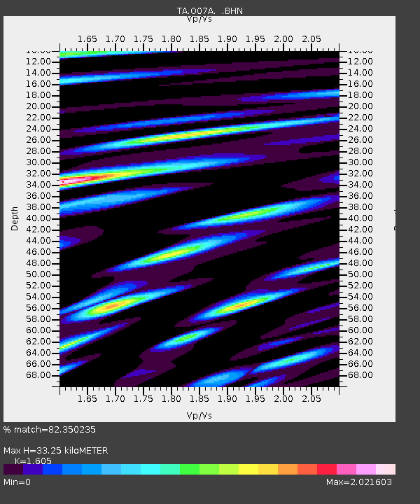
| Estimated Moho Depth: |
33.25 km |
| Estimated Crust Vp/Vs: |
1.61 |
| Assumed Crust Vp: |
6.276 km/s |
| Estimated Crust Vs: |
3.91 km/s |
| Estimated Crust Poisson's Ratio: |
0.18 |
|
| Radial Match: |
82.350235 % |
| Radial Bump: |
400 |
| Transverse Match: |
79.19832 % |
| Transverse Bump: |
400 |
| SOD ConfigId: |
2564 |
| Insert Time: |
2010-03-07 01:06:13.287 +0000 |
| GWidth: |
2.5 |
| Max Bumps: |
400 |
| Tol: |
0.001 |
|
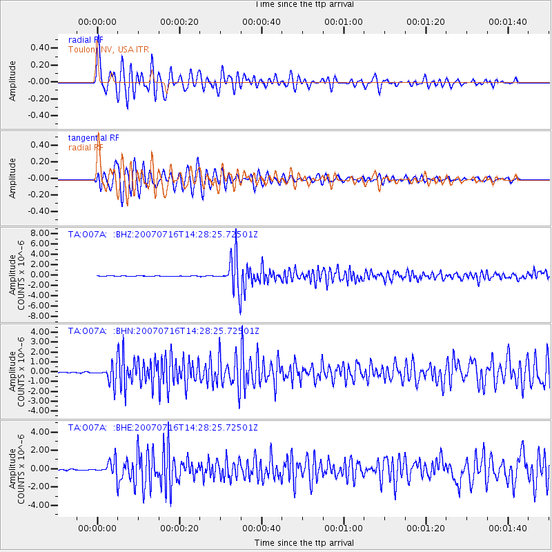
Signal To Noise
| Channel | StoN | STA | LTA |
| TA:O07A: :BHN:20070716T14:28:25.72501Z | 15.908565 | 9.015432E-7 | 5.6670306E-8 |
| TA:O07A: :BHE:20070716T14:28:25.72501Z | 13.426892 | 7.9695405E-7 | 5.9355067E-8 |
| TA:O07A: :BHZ:20070716T14:28:25.72501Z | 86.300415 | 3.2202847E-6 | 3.7314823E-8 |
| Arrivals |
| Ps | 3.3 SECOND |
| PpPs | 13 SECOND |
| PsPs/PpSs | 17 SECOND |


