You are here: Home > Network List > TA - USArray Transportable Network (new EarthScope stations) Stations List
> Station O07A Toulon, NV, USA > Earthquake Result Viewer
O07A Toulon, NV, USA - Earthquake Result Viewer
| Earthquake location: |
Near Coast Of Peru |
| Earthquake latitude/longitude: |
-13.5/-76.7 |
| Earthquake time(UTC): |
2006/10/20 (293) 10:48:56 GMT |
| Earthquake Depth: |
23 km |
| Earthquake Magnitude: |
5.9 MB, 6.6 MS, 6.7 MW, 6.6 MW |
| Earthquake Catalog/Contributor: |
WHDF/NEIC |
|
| Network: |
TA USArray Transportable Network (new EarthScope stations) |
| Station: |
O07A Toulon, NV, USA |
| Lat/Lon: |
40.16 N/118.88 W |
| Elevation: |
1203 m |
|
| Distance: |
66.2 deg |
| Az: |
325.758 deg |
| Baz: |
134.411 deg |
| Ray Param: |
0.05775358 |
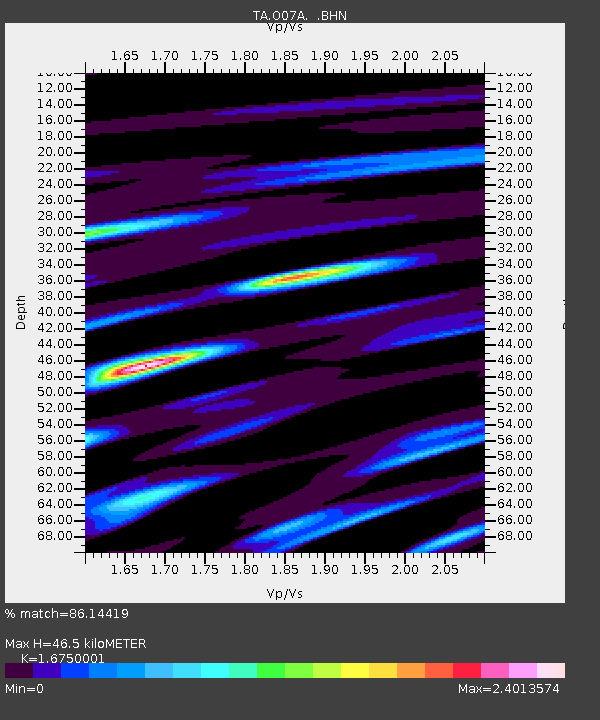
| Estimated Moho Depth: |
46.5 km |
| Estimated Crust Vp/Vs: |
1.68 |
| Assumed Crust Vp: |
6.276 km/s |
| Estimated Crust Vs: |
3.747 km/s |
| Estimated Crust Poisson's Ratio: |
0.22 |
|
| Radial Match: |
86.14419 % |
| Radial Bump: |
400 |
| Transverse Match: |
64.7022 % |
| Transverse Bump: |
400 |
| SOD ConfigId: |
2665 |
| Insert Time: |
2010-03-07 01:06:55.978 +0000 |
| GWidth: |
2.5 |
| Max Bumps: |
400 |
| Tol: |
0.001 |
|

Signal To Noise
| Channel | StoN | STA | LTA |
| TA:O07A: :BHN:20061020T10:59:10.650015Z | 2.413909 | 3.691762E-7 | 1.5293709E-7 |
| TA:O07A: :BHE:20061020T10:59:10.650015Z | 0.7749813 | 2.0989194E-7 | 2.7083485E-7 |
| TA:O07A: :BHZ:20061020T10:59:10.650015Z | 6.308563 | 8.882754E-7 | 1.4080472E-7 |
| Arrivals |
| Ps | 5.2 SECOND |
| PpPs | 19 SECOND |
| PsPs/PpSs | 24 SECOND |


