You are here: Home > Network List > UU - University of Utah Regional Network Stations List
> Station WPUT Wasatch Plateau, UT,USA > Earthquake Result Viewer
WPUT Wasatch Plateau, UT,USA - Earthquake Result Viewer
| Earthquake location: |
Solomon Islands |
| Earthquake latitude/longitude: |
-10.7/161.3 |
| Earthquake time(UTC): |
2016/12/08 (343) 17:38:46 GMT |
| Earthquake Depth: |
41 km |
| Earthquake Magnitude: |
7.8 mww |
| Earthquake Catalog/Contributor: |
NEIC PDE/us |
|
| Network: |
UU University of Utah Regional Network |
| Station: |
WPUT Wasatch Plateau, UT,USA |
| Lat/Lon: |
39.00 N/111.36 W |
| Elevation: |
2618 m |
|
| Distance: |
94.6 deg |
| Az: |
51.338 deg |
| Baz: |
260.045 deg |
| Ray Param: |
0.040995758 |
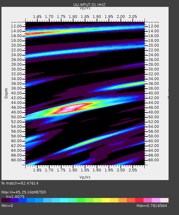
| Estimated Moho Depth: |
45.25 km |
| Estimated Crust Vp/Vs: |
1.81 |
| Assumed Crust Vp: |
6.207 km/s |
| Estimated Crust Vs: |
3.434 km/s |
| Estimated Crust Poisson's Ratio: |
0.28 |
|
| Radial Match: |
92.47614 % |
| Radial Bump: |
400 |
| Transverse Match: |
93.03563 % |
| Transverse Bump: |
384 |
| SOD ConfigId: |
1894071 |
| Insert Time: |
2016-12-22 17:42:48.772 +0000 |
| GWidth: |
2.5 |
| Max Bumps: |
400 |
| Tol: |
0.001 |
|

Signal To Noise
| Channel | StoN | STA | LTA |
| UU:WPUT:01:HHZ:20161208T17:51:31.249995Z | 9.896611 | 9.183753E-8 | 9.2796935E-9 |
| UU:WPUT:01:HHN:20161208T17:51:31.249995Z | 0.6724518 | 4.7367763E-9 | 7.0440382E-9 |
| UU:WPUT:01:HHE:20161208T17:51:31.249995Z | 2.9528427 | 2.5795604E-8 | 8.735854E-9 |
| Arrivals |
| Ps | 6.0 SECOND |
| PpPs | 20 SECOND |
| PsPs/PpSs | 26 SECOND |


