You are here: Home > Network List > N4 - Central and EAstern US Network Stations List
> Station M44A Midewin, Midewin Nat. Tallgrass Prarie, IL, USA > Earthquake Result Viewer
M44A Midewin, Midewin Nat. Tallgrass Prarie, IL, USA - Earthquake Result Viewer
| Earthquake location: |
Queen Charlotte Islands Region |
| Earthquake latitude/longitude: |
51.3/-130.6 |
| Earthquake time(UTC): |
2019/07/05 (186) 12:58:28 GMT |
| Earthquake Depth: |
5.1 km |
| Earthquake Magnitude: |
5.6 Mww |
| Earthquake Catalog/Contributor: |
NEIC PDE/us |
|
| Network: |
N4 Central and EAstern US Network |
| Station: |
M44A Midewin, Midewin Nat. Tallgrass Prarie, IL, USA |
| Lat/Lon: |
41.39 N/88.04 W |
| Elevation: |
207 m |
|
| Distance: |
30.6 deg |
| Az: |
92.104 deg |
| Baz: |
303.58 deg |
| Ray Param: |
0.07929723 |
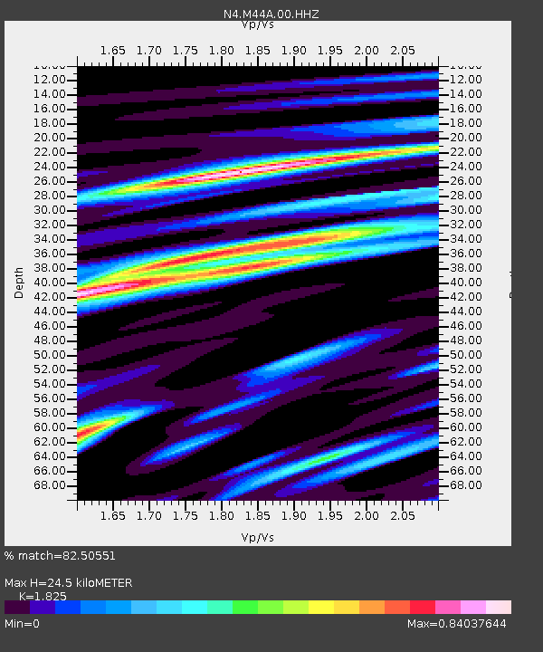
| Estimated Moho Depth: |
24.5 km |
| Estimated Crust Vp/Vs: |
1.83 |
| Assumed Crust Vp: |
6.498 km/s |
| Estimated Crust Vs: |
3.56 km/s |
| Estimated Crust Poisson's Ratio: |
0.29 |
|
| Radial Match: |
82.50551 % |
| Radial Bump: |
343 |
| Transverse Match: |
63.599895 % |
| Transverse Bump: |
400 |
| SOD ConfigId: |
19053131 |
| Insert Time: |
2019-07-19 13:01:19.052 +0000 |
| GWidth: |
2.5 |
| Max Bumps: |
400 |
| Tol: |
0.001 |
|

Signal To Noise
| Channel | StoN | STA | LTA |
| N4:M44A:00:HHZ:20190705T13:04:12.368997Z | 2.9573596 | 3.49186E-7 | 1.18073565E-7 |
| N4:M44A:00:HH1:20190705T13:04:12.368997Z | 1.7438368 | 1.3708478E-7 | 7.861102E-8 |
| N4:M44A:00:HH2:20190705T13:04:12.368997Z | 2.281905 | 2.1252517E-7 | 9.313497E-8 |
| Arrivals |
| Ps | 3.4 SECOND |
| PpPs | 9.8 SECOND |
| PsPs/PpSs | 13 SECOND |


