You are here: Home > Network List > US - United States National Seismic Network Stations List
> Station HAWA Hanford, Washington, USA > Earthquake Result Viewer
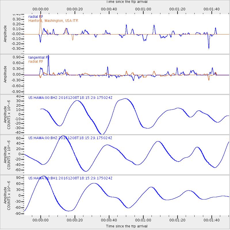
HAWA Hanford, Washington, USA - Earthquake Result Viewer
*The percent match for this event was below the threshold and hence no stack was calculated.
| Earthquake location: |
Solomon Islands |
| Earthquake latitude/longitude: |
-10.4/161.3 |
| Earthquake time(UTC): |
2016/12/08 (343) 18:03:05 GMT |
| Earthquake Depth: |
42 km |
| Earthquake Magnitude: |
5.6 mb |
| Earthquake Catalog/Contributor: |
NEIC PDE/us |
|
| Network: |
US United States National Seismic Network |
| Station: |
HAWA Hanford, Washington, USA |
| Lat/Lon: |
46.39 N/119.53 W |
| Elevation: |
364 m |
|
| Distance: |
90.1 deg |
| Az: |
42.824 deg |
| Baz: |
255.073 deg |
| Ray Param: |
$rayparam |
*The percent match for this event was below the threshold and hence was not used in the summary stack. |
|
| Radial Match: |
46.061527 % |
| Radial Bump: |
400 |
| Transverse Match: |
53.58868 % |
| Transverse Bump: |
230 |
| SOD ConfigId: |
1894071 |
| Insert Time: |
2016-12-22 18:04:50.070 +0000 |
| GWidth: |
2.5 |
| Max Bumps: |
400 |
| Tol: |
0.001 |
|
Signal To Noise
| Channel | StoN | STA | LTA |
| US:HAWA:00:BHZ:20161208T18:15:29.175024Z | 4.38016 | 3.529008E-5 | 8.056801E-6 |
| US:HAWA:00:BH1:20161208T18:15:29.175024Z | 2.263907 | 1.0772013E-4 | 4.7581518E-5 |
| US:HAWA:00:BH2:20161208T18:15:29.175024Z | 1.6592512 | 3.0672352E-5 | 1.8485658E-5 |
| Arrivals |
| Ps | |
| PpPs | |
| PsPs/PpSs | |


