You are here: Home > Network List > AT - Alaska Tsunami Warning Seismic System Stations List
> Station PMR Palmer, Alaska > Earthquake Result Viewer
PMR Palmer, Alaska - Earthquake Result Viewer
| Earthquake location: |
Central California |
| Earthquake latitude/longitude: |
35.8/-117.6 |
| Earthquake time(UTC): |
2019/07/06 (187) 03:19:53 GMT |
| Earthquake Depth: |
8.0 km |
| Earthquake Magnitude: |
7.1 mw |
| Earthquake Catalog/Contributor: |
NEIC PDE/ci |
|
| Network: |
AT Alaska Tsunami Warning Seismic System |
| Station: |
PMR Palmer, Alaska |
| Lat/Lon: |
61.59 N/149.13 W |
| Elevation: |
100 m |
|
| Distance: |
32.6 deg |
| Az: |
332.332 deg |
| Baz: |
127.848 deg |
| Ray Param: |
0.07859193 |
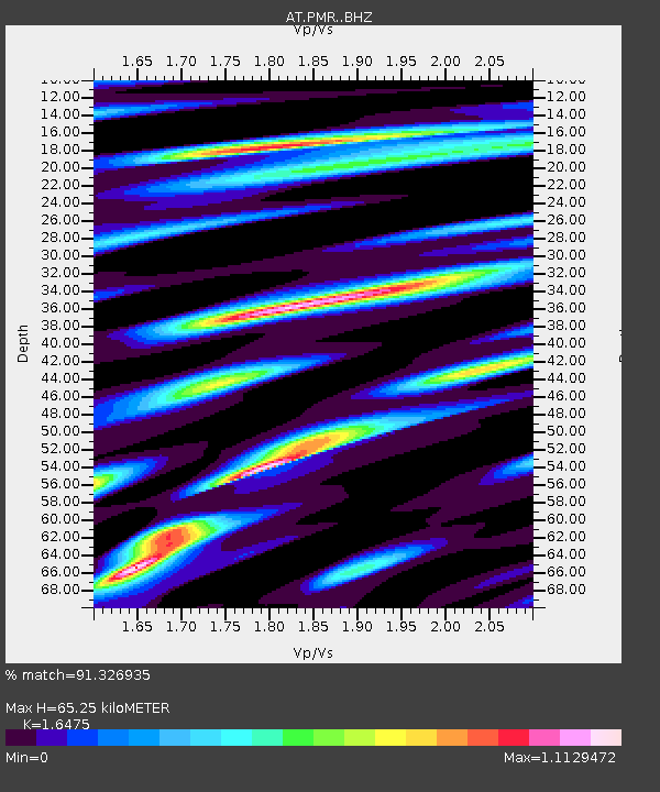
| Estimated Moho Depth: |
65.25 km |
| Estimated Crust Vp/Vs: |
1.65 |
| Assumed Crust Vp: |
6.566 km/s |
| Estimated Crust Vs: |
3.986 km/s |
| Estimated Crust Poisson's Ratio: |
0.21 |
|
| Radial Match: |
91.326935 % |
| Radial Bump: |
354 |
| Transverse Match: |
68.737465 % |
| Transverse Bump: |
400 |
| SOD ConfigId: |
19053131 |
| Insert Time: |
2019-07-20 03:21:10.643 +0000 |
| GWidth: |
2.5 |
| Max Bumps: |
400 |
| Tol: |
0.001 |
|

Signal To Noise
| Channel | StoN | STA | LTA |
| AT:PMR: :BHZ:20190706T03:25:54.140006Z | 1.7139968 | 1.4069217E-7 | 8.208426E-8 |
| AT:PMR: :BHN:20190706T03:25:54.140006Z | 0.86783135 | 5.3222937E-8 | 6.132866E-8 |
| AT:PMR: :BHE:20190706T03:25:54.140006Z | 2.80262 | 1.3801827E-7 | 4.9246157E-8 |
| Arrivals |
| Ps | 7.0 SECOND |
| PpPs | 24 SECOND |
| PsPs/PpSs | 31 SECOND |


