You are here: Home > Network List > AV - Alaska Volcano Observatory Stations List
> Station ETKA Kagalaska Island, Regional Station, Alaska > Earthquake Result Viewer
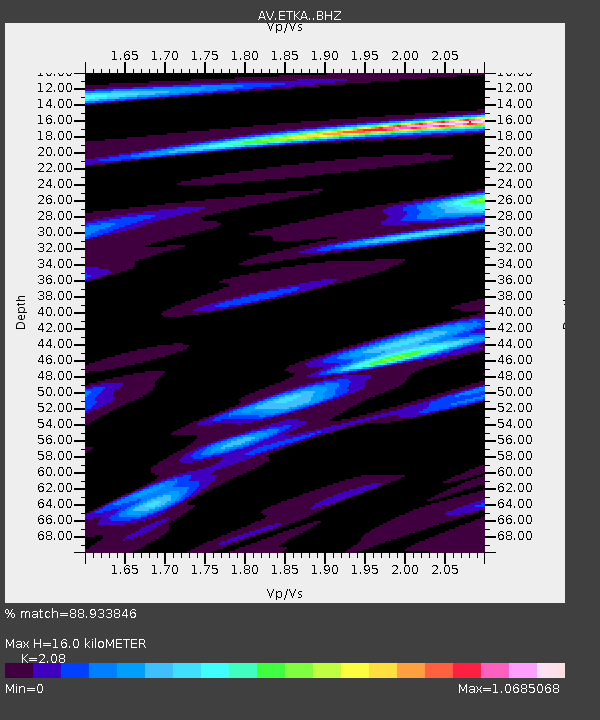
ETKA Kagalaska Island, Regional Station, Alaska - Earthquake Result Viewer
| Earthquake location: |
Central California |
| Earthquake latitude/longitude: |
35.8/-117.6 |
| Earthquake time(UTC): |
2019/07/06 (187) 03:19:53 GMT |
| Earthquake Depth: |
8.0 km |
| Earthquake Magnitude: |
7.1 mw |
| Earthquake Catalog/Contributor: |
NEIC PDE/ci |
|
| Network: |
AV Alaska Volcano Observatory |
| Station: |
ETKA Kagalaska Island, Regional Station, Alaska |
| Lat/Lon: |
51.86 N/176.41 W |
| Elevation: |
290 m |
|
| Distance: |
44.1 deg |
| Az: |
310.374 deg |
| Baz: |
87.491 deg |
| Ray Param: |
0.07210877 |
| Estimated Moho Depth: |
16.0 km |
| Estimated Crust Vp/Vs: |
2.08 |
| Assumed Crust Vp: |
5.88 km/s |
| Estimated Crust Vs: |
2.827 km/s |
| Estimated Crust Poisson's Ratio: |
0.35 |
|
| Radial Match: |
88.933846 % |
| Radial Bump: |
307 |
| Transverse Match: |
74.83315 % |
| Transverse Bump: |
378 |
| SOD ConfigId: |
19053131 |
| Insert Time: |
2019-07-20 03:21:29.435 +0000 |
| GWidth: |
2.5 |
| Max Bumps: |
400 |
| Tol: |
0.001 |
|

Signal To Noise
| Channel | StoN | STA | LTA |
| AV:ETKA: :BHZ:20190706T03:27:31.020011Z | 2.1319957 | 5.955828E-7 | 2.793546E-7 |
| AV:ETKA: :BHN:20190706T03:27:31.020011Z | 0.3274257 | 1.3494135E-7 | 4.1212814E-7 |
| AV:ETKA: :BHE:20190706T03:27:31.020011Z | 1.530735 | 4.084724E-7 | 2.6684722E-7 |
| Arrivals |
| Ps | 3.1 SECOND |
| PpPs | 8.0 SECOND |
| PsPs/PpSs | 11 SECOND |


