You are here: Home > Network List > TA - USArray Transportable Network (new EarthScope stations) Stations List
> Station I09A Lost Marbles Ranch, Westfall, OR, USA > Earthquake Result Viewer
I09A Lost Marbles Ranch, Westfall, OR, USA - Earthquake Result Viewer
| Earthquake location: |
Chile-Argentina Border Region |
| Earthquake latitude/longitude: |
-24.8/-68.5 |
| Earthquake time(UTC): |
2007/11/21 (325) 12:55:05 GMT |
| Earthquake Depth: |
115 km |
| Earthquake Magnitude: |
5.6 MB, 5.8 MW, 5.8 MW |
| Earthquake Catalog/Contributor: |
WHDF/NEIC |
|
| Network: |
TA USArray Transportable Network (new EarthScope stations) |
| Station: |
I09A Lost Marbles Ranch, Westfall, OR, USA |
| Lat/Lon: |
43.97 N/117.74 W |
| Elevation: |
950 m |
|
| Distance: |
82.0 deg |
| Az: |
326.461 deg |
| Baz: |
135.938 deg |
| Ray Param: |
0.046942387 |
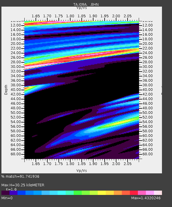
| Estimated Moho Depth: |
30.25 km |
| Estimated Crust Vp/Vs: |
1.60 |
| Assumed Crust Vp: |
6.291 km/s |
| Estimated Crust Vs: |
3.932 km/s |
| Estimated Crust Poisson's Ratio: |
0.18 |
|
| Radial Match: |
91.741936 % |
| Radial Bump: |
333 |
| Transverse Match: |
49.630573 % |
| Transverse Bump: |
319 |
| SOD ConfigId: |
2564 |
| Insert Time: |
2010-03-07 01:09:24.102 +0000 |
| GWidth: |
2.5 |
| Max Bumps: |
400 |
| Tol: |
0.001 |
|

Signal To Noise
| Channel | StoN | STA | LTA |
| TA:I09A: :BHN:20071121T13:06:41.649011Z | 0.98504925 | 2.19566E-7 | 2.228985E-7 |
| TA:I09A: :BHE:20071121T13:06:41.649011Z | 1.1912274 | 1.8451843E-7 | 1.5489773E-7 |
| TA:I09A: :BHZ:20071121T13:06:41.649011Z | 6.1966066 | 8.075184E-7 | 1.3031622E-7 |
| Arrivals |
| Ps | 3.0 SECOND |
| PpPs | 12 SECOND |
| PsPs/PpSs | 15 SECOND |


