You are here: Home > Network List > TA - USArray Transportable Network (new EarthScope stations) Stations List
> Station I09A Lost Marbles Ranch, Westfall, OR, USA > Earthquake Result Viewer
I09A Lost Marbles Ranch, Westfall, OR, USA - Earthquake Result Viewer
| Earthquake location: |
South Of Fiji Islands |
| Earthquake latitude/longitude: |
-25.8/179.5 |
| Earthquake time(UTC): |
2007/10/16 (289) 21:05:43 GMT |
| Earthquake Depth: |
509 km |
| Earthquake Magnitude: |
6.2 MB, 6.6 MW, 6.5 MW |
| Earthquake Catalog/Contributor: |
WHDF/NEIC |
|
| Network: |
TA USArray Transportable Network (new EarthScope stations) |
| Station: |
I09A Lost Marbles Ranch, Westfall, OR, USA |
| Lat/Lon: |
43.97 N/117.74 W |
| Elevation: |
950 m |
|
| Distance: |
90.1 deg |
| Az: |
39.922 deg |
| Baz: |
233.267 deg |
| Ray Param: |
0.041535165 |
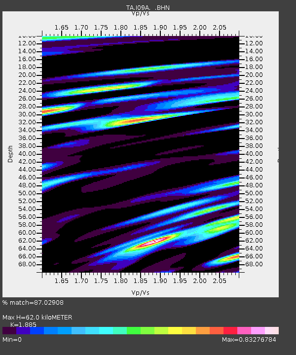
| Estimated Moho Depth: |
62.0 km |
| Estimated Crust Vp/Vs: |
1.88 |
| Assumed Crust Vp: |
6.291 km/s |
| Estimated Crust Vs: |
3.338 km/s |
| Estimated Crust Poisson's Ratio: |
0.30 |
|
| Radial Match: |
87.02908 % |
| Radial Bump: |
400 |
| Transverse Match: |
83.57317 % |
| Transverse Bump: |
400 |
| SOD ConfigId: |
2564 |
| Insert Time: |
2010-03-07 01:09:36.358 +0000 |
| GWidth: |
2.5 |
| Max Bumps: |
400 |
| Tol: |
0.001 |
|

Signal To Noise
| Channel | StoN | STA | LTA |
| TA:I09A: :BHN:20071016T21:17:16.949016Z | 5.445641 | 7.323978E-7 | 1.3449248E-7 |
| TA:I09A: :BHE:20071016T21:17:16.949016Z | 4.9408255 | 9.129227E-7 | 1.847713E-7 |
| TA:I09A: :BHZ:20071016T21:17:16.949016Z | 26.115326 | 3.5230908E-6 | 1.3490511E-7 |
| Arrivals |
| Ps | 8.9 SECOND |
| PpPs | 28 SECOND |
| PsPs/PpSs | 37 SECOND |


