You are here: Home > Network List > N4 - Central and EAstern US Network Stations List
> Station X58A Rowland, NC, USA > Earthquake Result Viewer
X58A Rowland, NC, USA - Earthquake Result Viewer
| Earthquake location: |
Central California |
| Earthquake latitude/longitude: |
35.8/-117.6 |
| Earthquake time(UTC): |
2019/07/06 (187) 03:19:53 GMT |
| Earthquake Depth: |
8.0 km |
| Earthquake Magnitude: |
7.1 mw |
| Earthquake Catalog/Contributor: |
NEIC PDE/ci |
|
| Network: |
N4 Central and EAstern US Network |
| Station: |
X58A Rowland, NC, USA |
| Lat/Lon: |
34.55 N/79.34 W |
| Elevation: |
45 m |
|
| Distance: |
31.2 deg |
| Az: |
80.883 deg |
| Baz: |
283.379 deg |
| Ray Param: |
0.079141274 |
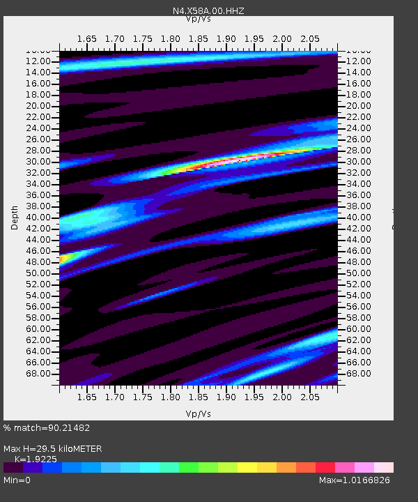
| Estimated Moho Depth: |
29.5 km |
| Estimated Crust Vp/Vs: |
1.92 |
| Assumed Crust Vp: |
6.565 km/s |
| Estimated Crust Vs: |
3.415 km/s |
| Estimated Crust Poisson's Ratio: |
0.31 |
|
| Radial Match: |
90.21482 % |
| Radial Bump: |
302 |
| Transverse Match: |
60.71316 % |
| Transverse Bump: |
400 |
| SOD ConfigId: |
19053131 |
| Insert Time: |
2019-07-20 03:24:08.839 +0000 |
| GWidth: |
2.5 |
| Max Bumps: |
400 |
| Tol: |
0.001 |
|

Signal To Noise
| Channel | StoN | STA | LTA |
| N4:X58A:00:HHZ:20190706T03:25:41.730002Z | 4.185177 | 5.028878E-7 | 1.2015927E-7 |
| N4:X58A:00:HH1:20190706T03:25:41.730002Z | 1.4335889 | 1.220641E-7 | 8.514581E-8 |
| N4:X58A:00:HH2:20190706T03:25:41.730002Z | 2.8639946 | 3.4426787E-7 | 1.202055E-7 |
| Arrivals |
| Ps | 4.5 SECOND |
| PpPs | 12 SECOND |
| PsPs/PpSs | 17 SECOND |


