You are here: Home > Network List > TA - USArray Transportable Network (new EarthScope stations) Stations List
> Station I09A Lost Marbles Ranch, Westfall, OR, USA > Earthquake Result Viewer
I09A Lost Marbles Ranch, Westfall, OR, USA - Earthquake Result Viewer
| Earthquake location: |
Guatemala |
| Earthquake latitude/longitude: |
14.4/-91.0 |
| Earthquake time(UTC): |
2007/07/23 (204) 22:30:08 GMT |
| Earthquake Depth: |
113 km |
| Earthquake Magnitude: |
5.5 MW, 5.3 MB, 5.5 MW |
| Earthquake Catalog/Contributor: |
WHDF/NEIC |
|
| Network: |
TA USArray Transportable Network (new EarthScope stations) |
| Station: |
I09A Lost Marbles Ranch, Westfall, OR, USA |
| Lat/Lon: |
43.97 N/117.74 W |
| Elevation: |
950 m |
|
| Distance: |
37.3 deg |
| Az: |
327.535 deg |
| Baz: |
133.906 deg |
| Ray Param: |
0.07582057 |
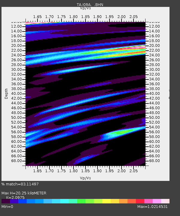
| Estimated Moho Depth: |
20.25 km |
| Estimated Crust Vp/Vs: |
2.10 |
| Assumed Crust Vp: |
6.291 km/s |
| Estimated Crust Vs: |
2.999 km/s |
| Estimated Crust Poisson's Ratio: |
0.35 |
|
| Radial Match: |
83.11497 % |
| Radial Bump: |
400 |
| Transverse Match: |
67.11541 % |
| Transverse Bump: |
400 |
| SOD ConfigId: |
2564 |
| Insert Time: |
2010-03-07 01:10:02.835 +0000 |
| GWidth: |
2.5 |
| Max Bumps: |
400 |
| Tol: |
0.001 |
|

Signal To Noise
| Channel | StoN | STA | LTA |
| TA:I09A: :BHN:20070723T22:36:39.325Z | 4.668821 | 3.676735E-7 | 7.875083E-8 |
| TA:I09A: :BHE:20070723T22:36:39.325Z | 6.021747 | 4.5899736E-7 | 7.622329E-8 |
| TA:I09A: :BHZ:20070723T22:36:39.325Z | 18.78929 | 1.0357961E-6 | 5.5126943E-8 |
| Arrivals |
| Ps | 3.7 SECOND |
| PpPs | 9.4 SECOND |
| PsPs/PpSs | 13 SECOND |


