You are here: Home > Network List > TA - USArray Transportable Network (new EarthScope stations) Stations List
> Station E19K Redstone River, AK, USA > Earthquake Result Viewer
E19K Redstone River, AK, USA - Earthquake Result Viewer
| Earthquake location: |
Central California |
| Earthquake latitude/longitude: |
35.8/-117.6 |
| Earthquake time(UTC): |
2019/07/06 (187) 03:19:53 GMT |
| Earthquake Depth: |
8.0 km |
| Earthquake Magnitude: |
7.1 mw |
| Earthquake Catalog/Contributor: |
NEIC PDE/ci |
|
| Network: |
TA USArray Transportable Network (new EarthScope stations) |
| Station: |
E19K Redstone River, AK, USA |
| Lat/Lon: |
67.46 N/157.23 W |
| Elevation: |
441 m |
|
| Distance: |
38.9 deg |
| Az: |
336.934 deg |
| Baz: |
124.274 deg |
| Ray Param: |
0.07531012 |
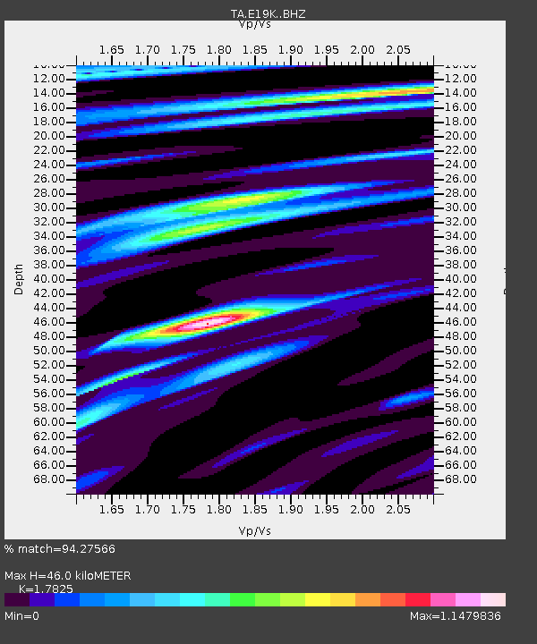
| Estimated Moho Depth: |
46.0 km |
| Estimated Crust Vp/Vs: |
1.78 |
| Assumed Crust Vp: |
6.577 km/s |
| Estimated Crust Vs: |
3.69 km/s |
| Estimated Crust Poisson's Ratio: |
0.27 |
|
| Radial Match: |
94.27566 % |
| Radial Bump: |
297 |
| Transverse Match: |
81.06065 % |
| Transverse Bump: |
400 |
| SOD ConfigId: |
19053131 |
| Insert Time: |
2019-07-20 03:25:12.729 +0000 |
| GWidth: |
2.5 |
| Max Bumps: |
400 |
| Tol: |
0.001 |
|

Signal To Noise
| Channel | StoN | STA | LTA |
| TA:E19K: :BHZ:20190706T03:26:47.999991Z | 1.9491299 | 1.4926226E-7 | 7.657892E-8 |
| TA:E19K: :BHN:20190706T03:26:47.999991Z | 1.4493219 | 5.475252E-8 | 3.7778026E-8 |
| TA:E19K: :BHE:20190706T03:26:47.999991Z | 1.5239531 | 6.967718E-8 | 4.572134E-8 |
| Arrivals |
| Ps | 5.9 SECOND |
| PpPs | 18 SECOND |
| PsPs/PpSs | 24 SECOND |


