You are here: Home > Network List > TA - USArray Transportable Network (new EarthScope stations) Stations List
> Station K17K Iditarod, AK, USA > Earthquake Result Viewer
K17K Iditarod, AK, USA - Earthquake Result Viewer
| Earthquake location: |
Central California |
| Earthquake latitude/longitude: |
35.8/-117.6 |
| Earthquake time(UTC): |
2019/07/06 (187) 03:19:53 GMT |
| Earthquake Depth: |
8.0 km |
| Earthquake Magnitude: |
7.1 mw |
| Earthquake Catalog/Contributor: |
NEIC PDE/ci |
|
| Network: |
TA USArray Transportable Network (new EarthScope stations) |
| Station: |
K17K Iditarod, AK, USA |
| Lat/Lon: |
62.72 N/158.30 W |
| Elevation: |
339 m |
|
| Distance: |
36.8 deg |
| Az: |
329.9 deg |
| Baz: |
117.746 deg |
| Ray Param: |
0.07648031 |
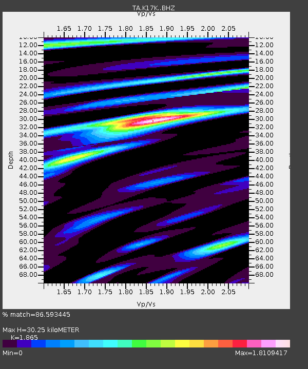
| Estimated Moho Depth: |
30.25 km |
| Estimated Crust Vp/Vs: |
1.87 |
| Assumed Crust Vp: |
6.276 km/s |
| Estimated Crust Vs: |
3.365 km/s |
| Estimated Crust Poisson's Ratio: |
0.30 |
|
| Radial Match: |
86.593445 % |
| Radial Bump: |
400 |
| Transverse Match: |
72.49893 % |
| Transverse Bump: |
400 |
| SOD ConfigId: |
19053131 |
| Insert Time: |
2019-07-20 03:25:30.357 +0000 |
| GWidth: |
2.5 |
| Max Bumps: |
400 |
| Tol: |
0.001 |
|

Signal To Noise
| Channel | StoN | STA | LTA |
| TA:K17K: :BHZ:20190706T03:26:30.575004Z | 2.1738057 | 1.8323763E-7 | 8.429347E-8 |
| TA:K17K: :BHN:20190706T03:26:30.575004Z | 1.0487856 | 7.8751874E-8 | 7.5088636E-8 |
| TA:K17K: :BHE:20190706T03:26:30.575004Z | 1.3555442 | 1.3336302E-7 | 9.8383374E-8 |
| Arrivals |
| Ps | 4.5 SECOND |
| PpPs | 13 SECOND |
| PsPs/PpSs | 17 SECOND |


