You are here: Home > Network List > TA - USArray Transportable Network (new EarthScope stations) Stations List
> Station M14K Bethel, AK, USA > Earthquake Result Viewer
M14K Bethel, AK, USA - Earthquake Result Viewer
| Earthquake location: |
Central California |
| Earthquake latitude/longitude: |
35.8/-117.6 |
| Earthquake time(UTC): |
2019/07/06 (187) 03:19:53 GMT |
| Earthquake Depth: |
8.0 km |
| Earthquake Magnitude: |
7.1 mw |
| Earthquake Catalog/Contributor: |
NEIC PDE/ci |
|
| Network: |
TA USArray Transportable Network (new EarthScope stations) |
| Station: |
M14K Bethel, AK, USA |
| Lat/Lon: |
60.75 N/161.96 W |
| Elevation: |
19 m |
|
| Distance: |
37.6 deg |
| Az: |
325.739 deg |
| Baz: |
111.213 deg |
| Ray Param: |
0.07606152 |
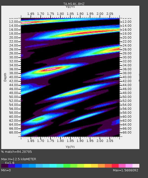
| Estimated Moho Depth: |
12.5 km |
| Estimated Crust Vp/Vs: |
1.60 |
| Assumed Crust Vp: |
6.182 km/s |
| Estimated Crust Vs: |
3.864 km/s |
| Estimated Crust Poisson's Ratio: |
0.18 |
|
| Radial Match: |
94.28785 % |
| Radial Bump: |
400 |
| Transverse Match: |
71.00931 % |
| Transverse Bump: |
400 |
| SOD ConfigId: |
19053131 |
| Insert Time: |
2019-07-20 03:25:34.997 +0000 |
| GWidth: |
2.5 |
| Max Bumps: |
400 |
| Tol: |
0.001 |
|

Signal To Noise
| Channel | StoN | STA | LTA |
| TA:M14K: :BHZ:20190706T03:26:37.075004Z | 2.405724 | 2.7079238E-7 | 1.1256171E-7 |
| TA:M14K: :BHN:20190706T03:26:37.075004Z | 1.5809351 | 2.5551742E-7 | 1.6162423E-7 |
| TA:M14K: :BHE:20190706T03:26:37.075004Z | 1.1949903 | 2.0288776E-7 | 1.6978193E-7 |
| Arrivals |
| Ps | 1.3 SECOND |
| PpPs | 4.9 SECOND |
| PsPs/PpSs | 6.2 SECOND |


