You are here: Home > Network List > TA - USArray Transportable Network (new EarthScope stations) Stations List
> Station M17K Holitna River, AK, USA > Earthquake Result Viewer
M17K Holitna River, AK, USA - Earthquake Result Viewer
| Earthquake location: |
Central California |
| Earthquake latitude/longitude: |
35.8/-117.6 |
| Earthquake time(UTC): |
2019/07/06 (187) 03:19:53 GMT |
| Earthquake Depth: |
8.0 km |
| Earthquake Magnitude: |
7.1 mw |
| Earthquake Catalog/Contributor: |
NEIC PDE/ci |
|
| Network: |
TA USArray Transportable Network (new EarthScope stations) |
| Station: |
M17K Holitna River, AK, USA |
| Lat/Lon: |
61.40 N/157.44 W |
| Elevation: |
387 m |
|
| Distance: |
35.8 deg |
| Az: |
328.239 deg |
| Baz: |
117.17 deg |
| Ray Param: |
0.07700869 |
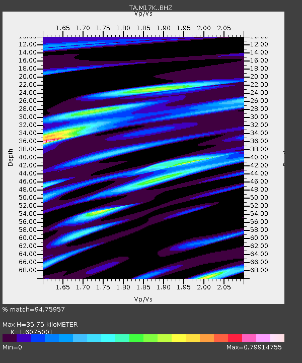
| Estimated Moho Depth: |
35.75 km |
| Estimated Crust Vp/Vs: |
1.61 |
| Assumed Crust Vp: |
6.155 km/s |
| Estimated Crust Vs: |
3.829 km/s |
| Estimated Crust Poisson's Ratio: |
0.18 |
|
| Radial Match: |
94.75957 % |
| Radial Bump: |
279 |
| Transverse Match: |
81.65971 % |
| Transverse Bump: |
400 |
| SOD ConfigId: |
19053131 |
| Insert Time: |
2019-07-20 03:25:35.916 +0000 |
| GWidth: |
2.5 |
| Max Bumps: |
400 |
| Tol: |
0.001 |
|

Signal To Noise
| Channel | StoN | STA | LTA |
| TA:M17K: :BHZ:20190706T03:26:22.30001Z | 2.5906847 | 2.198336E-7 | 8.485541E-8 |
| TA:M17K: :BHN:20190706T03:26:22.30001Z | 0.7751844 | 5.3325564E-8 | 6.879081E-8 |
| TA:M17K: :BHE:20190706T03:26:22.30001Z | 1.2616086 | 9.7101456E-8 | 7.696639E-8 |
| Arrivals |
| Ps | 3.8 SECOND |
| PpPs | 14 SECOND |
| PsPs/PpSs | 18 SECOND |


