You are here: Home > Network List > TA - USArray Transportable Network (new EarthScope stations) Stations List
> Station I09A Lost Marbles Ranch, Westfall, OR, USA > Earthquake Result Viewer
I09A Lost Marbles Ranch, Westfall, OR, USA - Earthquake Result Viewer
| Earthquake location: |
East Of Kuril Islands |
| Earthquake latitude/longitude: |
46.2/154.4 |
| Earthquake time(UTC): |
2006/12/07 (341) 19:10:21 GMT |
| Earthquake Depth: |
16 km |
| Earthquake Magnitude: |
6.3 MB, 6.1 MS, 6.3 MW, 6.3 MW |
| Earthquake Catalog/Contributor: |
WHDF/NEIC |
|
| Network: |
TA USArray Transportable Network (new EarthScope stations) |
| Station: |
I09A Lost Marbles Ranch, Westfall, OR, USA |
| Lat/Lon: |
43.97 N/117.74 W |
| Elevation: |
950 m |
|
| Distance: |
58.9 deg |
| Az: |
57.383 deg |
| Baz: |
305.808 deg |
| Ray Param: |
0.06250667 |
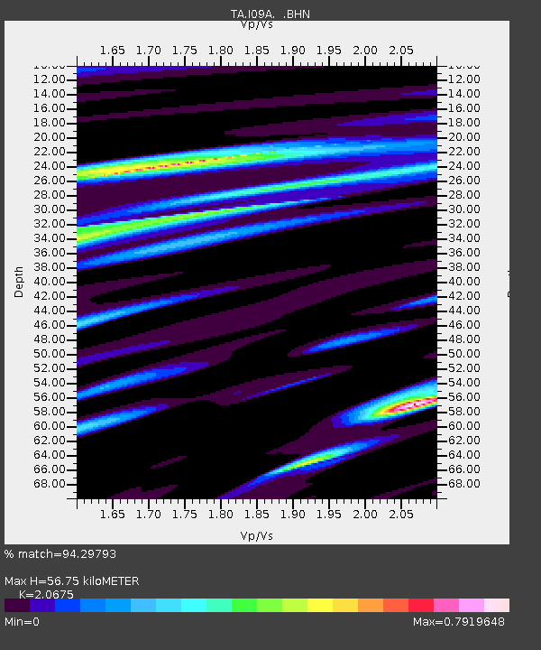
| Estimated Moho Depth: |
56.75 km |
| Estimated Crust Vp/Vs: |
2.07 |
| Assumed Crust Vp: |
6.291 km/s |
| Estimated Crust Vs: |
3.043 km/s |
| Estimated Crust Poisson's Ratio: |
0.35 |
|
| Radial Match: |
94.29793 % |
| Radial Bump: |
400 |
| Transverse Match: |
78.99246 % |
| Transverse Bump: |
400 |
| SOD ConfigId: |
2564 |
| Insert Time: |
2010-03-07 01:10:22.728 +0000 |
| GWidth: |
2.5 |
| Max Bumps: |
400 |
| Tol: |
0.001 |
|

Signal To Noise
| Channel | StoN | STA | LTA |
| TA:I09A: :BHN:20061207T19:19:49.125024Z | 2.3299532 | 5.5157267E-7 | 2.3673122E-7 |
| TA:I09A: :BHE:20061207T19:19:49.125024Z | 4.5919785 | 7.376728E-7 | 1.6064378E-7 |
| TA:I09A: :BHZ:20061207T19:19:49.125024Z | 6.710211 | 1.4436438E-6 | 2.1514134E-7 |
| Arrivals |
| Ps | 10 SECOND |
| PpPs | 27 SECOND |
| PsPs/PpSs | 37 SECOND |


