You are here: Home > Network List > TA - USArray Transportable Network (new EarthScope stations) Stations List
> Station I09A Lost Marbles Ranch, Westfall, OR, USA > Earthquake Result Viewer
I09A Lost Marbles Ranch, Westfall, OR, USA - Earthquake Result Viewer
| Earthquake location: |
Near Coast Of Peru |
| Earthquake latitude/longitude: |
-13.5/-76.7 |
| Earthquake time(UTC): |
2006/10/20 (293) 10:48:56 GMT |
| Earthquake Depth: |
23 km |
| Earthquake Magnitude: |
5.9 MB, 6.6 MS, 6.7 MW, 6.6 MW |
| Earthquake Catalog/Contributor: |
WHDF/NEIC |
|
| Network: |
TA USArray Transportable Network (new EarthScope stations) |
| Station: |
I09A Lost Marbles Ranch, Westfall, OR, USA |
| Lat/Lon: |
43.97 N/117.74 W |
| Elevation: |
950 m |
|
| Distance: |
68.3 deg |
| Az: |
329.308 deg |
| Baz: |
136.544 deg |
| Ray Param: |
0.056361325 |
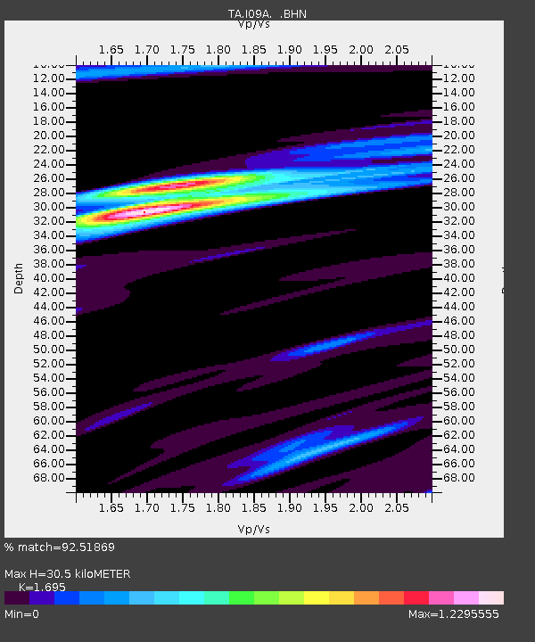
| Estimated Moho Depth: |
30.5 km |
| Estimated Crust Vp/Vs: |
1.70 |
| Assumed Crust Vp: |
6.291 km/s |
| Estimated Crust Vs: |
3.712 km/s |
| Estimated Crust Poisson's Ratio: |
0.23 |
|
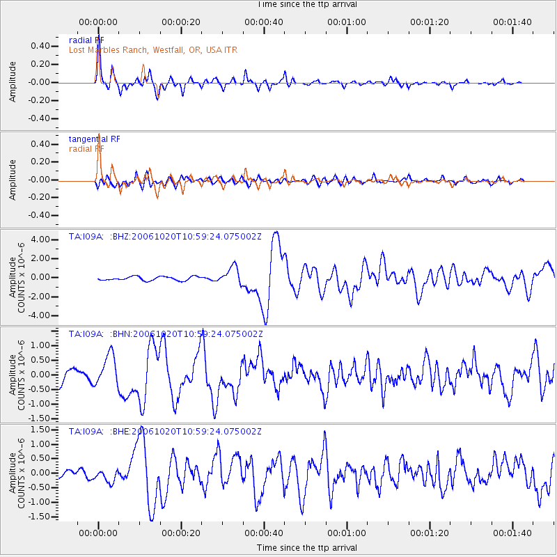
| Radial Match: |
92.51869 % |
| Radial Bump: |
272 |
| Transverse Match: |
71.13625 % |
| Transverse Bump: |
400 |
| SOD ConfigId: |
2564 |
| Insert Time: |
2010-03-07 01:10:26.953 +0000 |
| GWidth: |
2.5 |
| Max Bumps: |
400 |
| Tol: |
0.001 |
|
Signal To Noise
| Channel | StoN | STA | LTA |
| TA:I09A: :BHN:20061020T10:59:24.075002Z | 1.917365 | 5.4686996E-7 | 2.8521953E-7 |
| TA:I09A: :BHE:20061020T10:59:24.075002Z | 1.294581 | 2.230229E-7 | 1.7227417E-7 |
| TA:I09A: :BHZ:20061020T10:59:24.075002Z | 4.491092 | 9.327448E-7 | 2.0768773E-7 |
| Arrivals |
| Ps | 3.5 SECOND |
| PpPs | 13 SECOND |
| PsPs/PpSs | 16 SECOND |


