You are here: Home > Network List > TA - USArray Transportable Network (new EarthScope stations) Stations List
> Station I09A Lost Marbles Ranch, Westfall, OR, USA > Earthquake Result Viewer
I09A Lost Marbles Ranch, Westfall, OR, USA - Earthquake Result Viewer
| Earthquake location: |
Oaxaca, Mexico |
| Earthquake latitude/longitude: |
16.2/-97.3 |
| Earthquake time(UTC): |
2006/08/19 (231) 05:41:28 GMT |
| Earthquake Depth: |
32 km |
| Earthquake Magnitude: |
5.1 MB, 5.1 MS, 5.6 MW, 5.6 MW |
| Earthquake Catalog/Contributor: |
WHDF/NEIC |
|
| Network: |
TA USArray Transportable Network (new EarthScope stations) |
| Station: |
I09A Lost Marbles Ranch, Westfall, OR, USA |
| Lat/Lon: |
43.97 N/117.74 W |
| Elevation: |
950 m |
|
| Distance: |
32.7 deg |
| Az: |
332.081 deg |
| Baz: |
141.465 deg |
| Ray Param: |
0.07851121 |
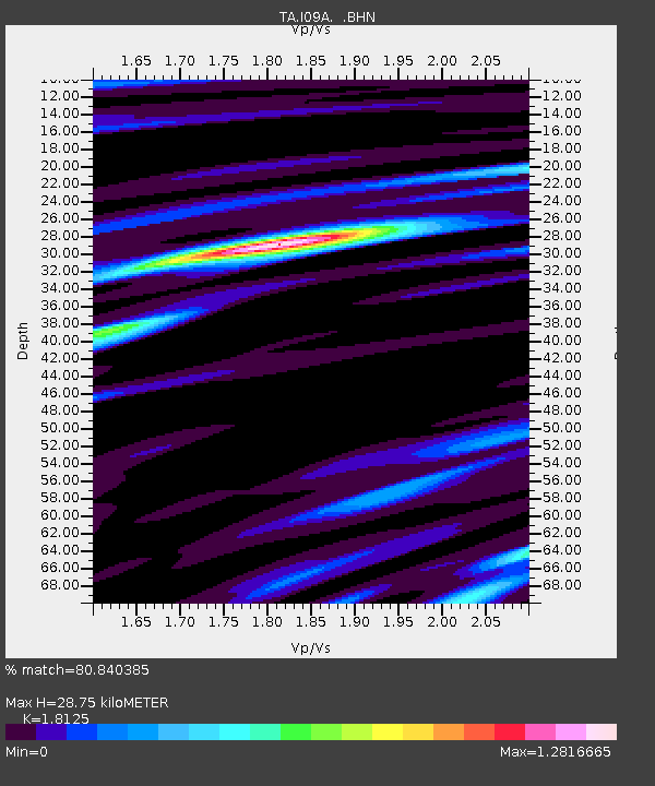
| Estimated Moho Depth: |
28.75 km |
| Estimated Crust Vp/Vs: |
1.81 |
| Assumed Crust Vp: |
6.291 km/s |
| Estimated Crust Vs: |
3.471 km/s |
| Estimated Crust Poisson's Ratio: |
0.28 |
|
| Radial Match: |
80.840385 % |
| Radial Bump: |
367 |
| Transverse Match: |
80.374214 % |
| Transverse Bump: |
400 |
| SOD ConfigId: |
2564 |
| Insert Time: |
2010-03-07 01:10:31.037 +0000 |
| GWidth: |
2.5 |
| Max Bumps: |
400 |
| Tol: |
0.001 |
|

Signal To Noise
| Channel | StoN | STA | LTA |
| TA:I09A: :BHN:20060819T05:47:27.200012Z | 3.3737798 | 1.939308E-7 | 5.748176E-8 |
| TA:I09A: :BHE:20060819T05:47:27.200012Z | 2.8666275 | 1.8619295E-7 | 6.495191E-8 |
| TA:I09A: :BHZ:20060819T05:47:27.200012Z | 6.724907 | 4.68074E-7 | 6.960305E-8 |
| Arrivals |
| Ps | 4.0 SECOND |
| PpPs | 12 SECOND |
| PsPs/PpSs | 16 SECOND |


