You are here: Home > Network List > TA - USArray Transportable Network (new EarthScope stations) Stations List
> Station I09A Lost Marbles Ranch, Westfall, OR, USA > Earthquake Result Viewer
I09A Lost Marbles Ranch, Westfall, OR, USA - Earthquake Result Viewer
| Earthquake location: |
Chile-Argentina Border Region |
| Earthquake latitude/longitude: |
-24.4/-67.0 |
| Earthquake time(UTC): |
2006/08/25 (237) 00:44:46 GMT |
| Earthquake Depth: |
184 km |
| Earthquake Magnitude: |
5.9 MB, 6.6 MW, 6.6 MW |
| Earthquake Catalog/Contributor: |
WHDF/NEIC |
|
| Network: |
TA USArray Transportable Network (new EarthScope stations) |
| Station: |
I09A Lost Marbles Ranch, Westfall, OR, USA |
| Lat/Lon: |
43.97 N/117.74 W |
| Elevation: |
950 m |
|
| Distance: |
82.4 deg |
| Az: |
325.683 deg |
| Baz: |
134.61 deg |
| Ray Param: |
0.046482965 |
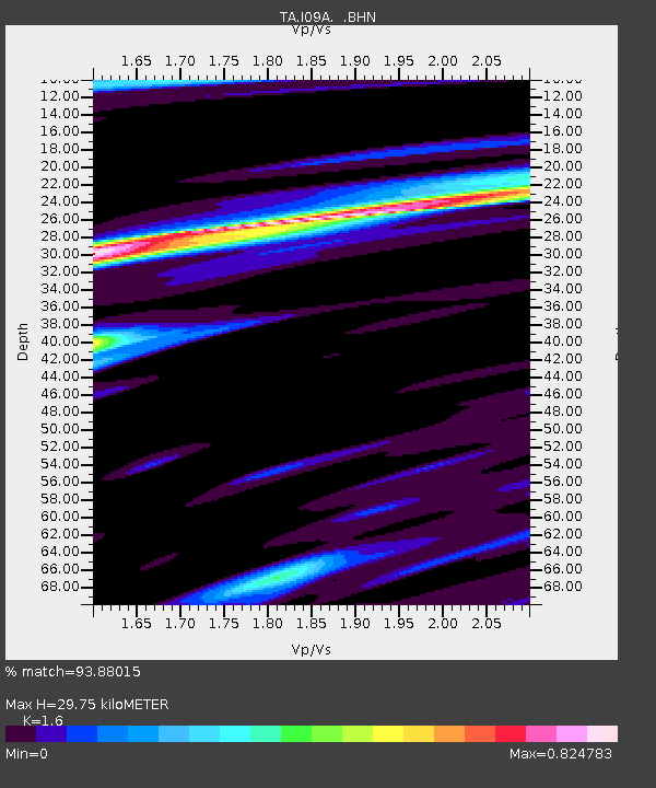
| Estimated Moho Depth: |
29.75 km |
| Estimated Crust Vp/Vs: |
1.60 |
| Assumed Crust Vp: |
6.291 km/s |
| Estimated Crust Vs: |
3.932 km/s |
| Estimated Crust Poisson's Ratio: |
0.18 |
|
| Radial Match: |
93.88015 % |
| Radial Bump: |
400 |
| Transverse Match: |
83.67181 % |
| Transverse Bump: |
400 |
| SOD ConfigId: |
2665 |
| Insert Time: |
2010-03-07 01:10:43.522 +0000 |
| GWidth: |
2.5 |
| Max Bumps: |
400 |
| Tol: |
0.001 |
|

Signal To Noise
| Channel | StoN | STA | LTA |
| TA:I09A: :BHN:20060825T00:56:16.349006Z | 9.346853 | 6.287836E-7 | 6.727222E-8 |
| TA:I09A: :BHE:20060825T00:56:16.349006Z | 11.361672 | 6.619874E-7 | 5.8264956E-8 |
| TA:I09A: :BHZ:20060825T00:56:16.349006Z | 26.68298 | 2.3691719E-6 | 8.8789626E-8 |
| Arrivals |
| Ps | 2.9 SECOND |
| PpPs | 12 SECOND |
| PsPs/PpSs | 15 SECOND |


