You are here: Home > Network List > TA - USArray Transportable Network (new EarthScope stations) Stations List
> Station B18K Kokolik River, AK, USA > Earthquake Result Viewer
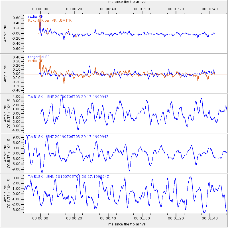
B18K Kokolik River, AK, USA - Earthquake Result Viewer
*The percent match for this event was below the threshold and hence no stack was calculated.
| Earthquake location: |
Central California |
| Earthquake latitude/longitude: |
35.9/-117.7 |
| Earthquake time(UTC): |
2019/07/06 (187) 03:22:03 GMT |
| Earthquake Depth: |
9.1 km |
| Earthquake Magnitude: |
4.6 Mlr |
| Earthquake Catalog/Contributor: |
NEIC PDE/ci |
|
| Network: |
TA USArray Transportable Network (new EarthScope stations) |
| Station: |
B18K Kokolik River, AK, USA |
| Lat/Lon: |
69.36 N/161.80 W |
| Elevation: |
222 m |
|
| Distance: |
41.2 deg |
| Az: |
337.995 deg |
| Baz: |
120.921 deg |
| Ray Param: |
$rayparam |
*The percent match for this event was below the threshold and hence was not used in the summary stack. |
|
| Radial Match: |
76.83543 % |
| Radial Bump: |
400 |
| Transverse Match: |
71.993935 % |
| Transverse Bump: |
400 |
| SOD ConfigId: |
19053131 |
| Insert Time: |
2019-07-20 03:29:15.268 +0000 |
| GWidth: |
2.5 |
| Max Bumps: |
400 |
| Tol: |
0.001 |
|
Signal To Noise
| Channel | StoN | STA | LTA |
| TA:B18K: :BHZ:20190706T03:29:17.199994Z | 1.5454258 | 6.87937E-6 | 4.4514404E-6 |
| TA:B18K: :BHN:20190706T03:29:17.199994Z | 1.0067886 | 1.1699217E-6 | 1.1620332E-6 |
| TA:B18K: :BHE:20190706T03:29:17.199994Z | 0.77259547 | 1.3652726E-6 | 1.7671249E-6 |
| Arrivals |
| Ps | |
| PpPs | |
| PsPs/PpSs | |


