You are here: Home > Network List > TA - USArray Transportable Network (new EarthScope stations) Stations List
> Station C26K Camden Bay, AK, USA > Earthquake Result Viewer
C26K Camden Bay, AK, USA - Earthquake Result Viewer
| Earthquake location: |
Central California |
| Earthquake latitude/longitude: |
35.9/-117.7 |
| Earthquake time(UTC): |
2019/07/06 (187) 03:22:03 GMT |
| Earthquake Depth: |
9.1 km |
| Earthquake Magnitude: |
4.6 Mlr |
| Earthquake Catalog/Contributor: |
NEIC PDE/ci |
|
| Network: |
TA USArray Transportable Network (new EarthScope stations) |
| Station: |
C26K Camden Bay, AK, USA |
| Lat/Lon: |
69.92 N/144.91 W |
| Elevation: |
139 m |
|
| Distance: |
37.1 deg |
| Az: |
344.835 deg |
| Baz: |
142.068 deg |
| Ray Param: |
0.07631989 |
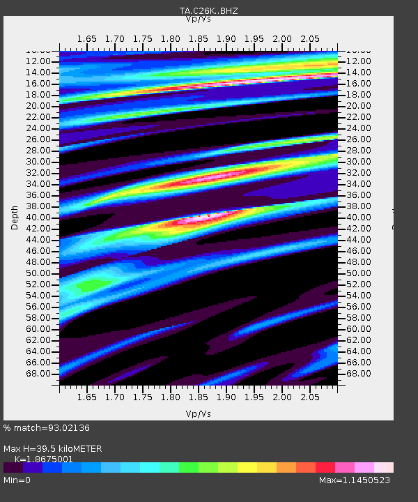
| Estimated Moho Depth: |
39.5 km |
| Estimated Crust Vp/Vs: |
1.87 |
| Assumed Crust Vp: |
6.455 km/s |
| Estimated Crust Vs: |
3.457 km/s |
| Estimated Crust Poisson's Ratio: |
0.30 |
|
| Radial Match: |
93.02136 % |
| Radial Bump: |
400 |
| Transverse Match: |
73.76812 % |
| Transverse Bump: |
400 |
| SOD ConfigId: |
19053131 |
| Insert Time: |
2019-07-20 03:29:17.113 +0000 |
| GWidth: |
2.5 |
| Max Bumps: |
400 |
| Tol: |
0.001 |
|

Signal To Noise
| Channel | StoN | STA | LTA |
| TA:C26K: :BHZ:20190706T03:28:43.349988Z | 1.2534308 | 1.2433391E-5 | 9.919487E-6 |
| TA:C26K: :BHN:20190706T03:28:43.349988Z | 0.94318515 | 6.170941E-6 | 6.5426616E-6 |
| TA:C26K: :BHE:20190706T03:28:43.349988Z | 1.191474 | 6.633119E-6 | 5.567154E-6 |
| Arrivals |
| Ps | 5.7 SECOND |
| PpPs | 16 SECOND |
| PsPs/PpSs | 22 SECOND |


