You are here: Home > Network List > TA - USArray Transportable Network (new EarthScope stations) Stations List
> Station E21K Killik River, AK, USA > Earthquake Result Viewer
E21K Killik River, AK, USA - Earthquake Result Viewer
| Earthquake location: |
Central California |
| Earthquake latitude/longitude: |
35.9/-117.7 |
| Earthquake time(UTC): |
2019/07/06 (187) 03:22:03 GMT |
| Earthquake Depth: |
9.1 km |
| Earthquake Magnitude: |
4.6 Mlr |
| Earthquake Catalog/Contributor: |
NEIC PDE/ci |
|
| Network: |
TA USArray Transportable Network (new EarthScope stations) |
| Station: |
E21K Killik River, AK, USA |
| Lat/Lon: |
68.44 N/153.97 W |
| Elevation: |
653 m |
|
| Distance: |
38.3 deg |
| Az: |
339.359 deg |
| Baz: |
129.27 deg |
| Ray Param: |
0.07563867 |
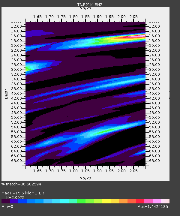
| Estimated Moho Depth: |
15.5 km |
| Estimated Crust Vp/Vs: |
2.10 |
| Assumed Crust Vp: |
6.221 km/s |
| Estimated Crust Vs: |
2.966 km/s |
| Estimated Crust Poisson's Ratio: |
0.35 |
|
| Radial Match: |
86.502594 % |
| Radial Bump: |
400 |
| Transverse Match: |
63.15199 % |
| Transverse Bump: |
400 |
| SOD ConfigId: |
19053131 |
| Insert Time: |
2019-07-20 03:29:19.667 +0000 |
| GWidth: |
2.5 |
| Max Bumps: |
400 |
| Tol: |
0.001 |
|

Signal To Noise
| Channel | StoN | STA | LTA |
| TA:E21K: :BHZ:20190706T03:28:53.525006Z | 0.7736113 | 3.7815084E-6 | 4.8881243E-6 |
| TA:E21K: :BHN:20190706T03:28:53.525006Z | 1.221812 | 2.7888766E-6 | 2.2825743E-6 |
| TA:E21K: :BHE:20190706T03:28:53.525006Z | 1.2865589 | 4.071927E-6 | 3.1649752E-6 |
| Arrivals |
| Ps | 2.9 SECOND |
| PpPs | 7.3 SECOND |
| PsPs/PpSs | 10 SECOND |


