You are here: Home > Network List > TA - USArray Transportable Network (new EarthScope stations) Stations List
> Station H17K Granite Mountain, AK, USA > Earthquake Result Viewer
H17K Granite Mountain, AK, USA - Earthquake Result Viewer
| Earthquake location: |
Central California |
| Earthquake latitude/longitude: |
35.9/-117.7 |
| Earthquake time(UTC): |
2019/07/06 (187) 03:22:03 GMT |
| Earthquake Depth: |
9.1 km |
| Earthquake Magnitude: |
4.6 Mlr |
| Earthquake Catalog/Contributor: |
NEIC PDE/ci |
|
| Network: |
TA USArray Transportable Network (new EarthScope stations) |
| Station: |
H17K Granite Mountain, AK, USA |
| Lat/Lon: |
64.94 N/159.91 W |
| Elevation: |
396 m |
|
| Distance: |
38.3 deg |
| Az: |
332.522 deg |
| Baz: |
118.45 deg |
| Ray Param: |
0.07563652 |
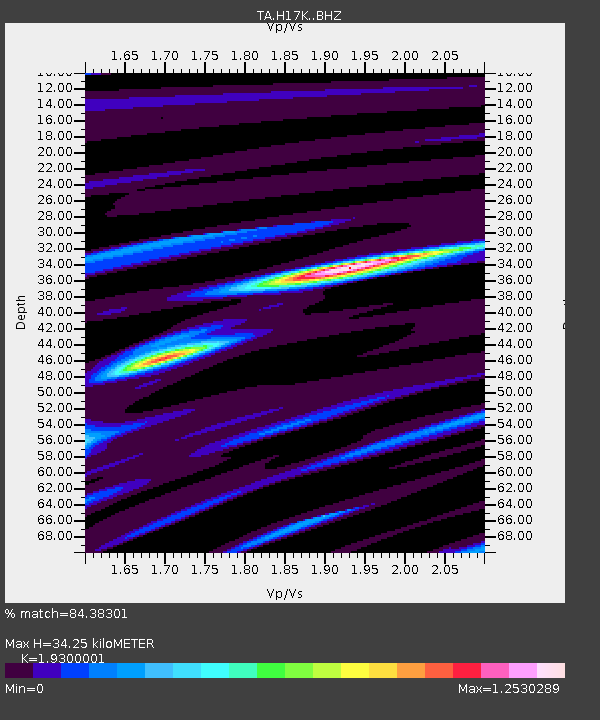
| Estimated Moho Depth: |
34.25 km |
| Estimated Crust Vp/Vs: |
1.93 |
| Assumed Crust Vp: |
6.1 km/s |
| Estimated Crust Vs: |
3.161 km/s |
| Estimated Crust Poisson's Ratio: |
0.32 |
|
| Radial Match: |
84.38301 % |
| Radial Bump: |
307 |
| Transverse Match: |
54.281914 % |
| Transverse Bump: |
400 |
| SOD ConfigId: |
19053131 |
| Insert Time: |
2019-07-20 03:29:26.938 +0000 |
| GWidth: |
2.5 |
| Max Bumps: |
400 |
| Tol: |
0.001 |
|

Signal To Noise
| Channel | StoN | STA | LTA |
| TA:H17K: :BHZ:20190706T03:28:53.550Z | 1.5996257 | 4.916152E-6 | 3.073314E-6 |
| TA:H17K: :BHN:20190706T03:28:53.550Z | 1.2199228 | 1.673126E-6 | 1.3715015E-6 |
| TA:H17K: :BHE:20190706T03:28:53.550Z | 1.0630654 | 3.0504689E-6 | 2.8695026E-6 |
| Arrivals |
| Ps | 5.5 SECOND |
| PpPs | 16 SECOND |
| PsPs/PpSs | 21 SECOND |


