You are here: Home > Network List > TA - USArray Transportable Network (new EarthScope stations) Stations List
> Station I17K Unalakleet, AK, USA > Earthquake Result Viewer
I17K Unalakleet, AK, USA - Earthquake Result Viewer
| Earthquake location: |
Central California |
| Earthquake latitude/longitude: |
35.9/-117.7 |
| Earthquake time(UTC): |
2019/07/06 (187) 03:22:03 GMT |
| Earthquake Depth: |
9.1 km |
| Earthquake Magnitude: |
4.6 Mlr |
| Earthquake Catalog/Contributor: |
NEIC PDE/ci |
|
| Network: |
TA USArray Transportable Network (new EarthScope stations) |
| Station: |
I17K Unalakleet, AK, USA |
| Lat/Lon: |
63.89 N/160.70 W |
| Elevation: |
105 m |
|
| Distance: |
38.1 deg |
| Az: |
330.756 deg |
| Baz: |
116.357 deg |
| Ray Param: |
0.075742766 |
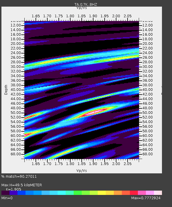
| Estimated Moho Depth: |
49.5 km |
| Estimated Crust Vp/Vs: |
1.90 |
| Assumed Crust Vp: |
6.276 km/s |
| Estimated Crust Vs: |
3.294 km/s |
| Estimated Crust Poisson's Ratio: |
0.31 |
|
| Radial Match: |
90.27011 % |
| Radial Bump: |
361 |
| Transverse Match: |
68.04702 % |
| Transverse Bump: |
400 |
| SOD ConfigId: |
19053131 |
| Insert Time: |
2019-07-20 03:29:29.044 +0000 |
| GWidth: |
2.5 |
| Max Bumps: |
400 |
| Tol: |
0.001 |
|

Signal To Noise
| Channel | StoN | STA | LTA |
| TA:I17K: :BHZ:20190706T03:28:52.025006Z | 1.2087333 | 4.485044E-6 | 3.7105322E-6 |
| TA:I17K: :BHN:20190706T03:28:52.025006Z | 0.84816945 | 1.6899112E-6 | 1.9924216E-6 |
| TA:I17K: :BHE:20190706T03:28:52.025006Z | 1.3767307 | 4.095556E-6 | 2.9748417E-6 |
| Arrivals |
| Ps | 7.6 SECOND |
| PpPs | 21 SECOND |
| PsPs/PpSs | 29 SECOND |


