You are here: Home > Network List > TA - USArray Transportable Network (new EarthScope stations) Stations List
> Station N08A GE Springer Mine, Mill City, NV, USA > Earthquake Result Viewer
N08A GE Springer Mine, Mill City, NV, USA - Earthquake Result Viewer
| Earthquake location: |
Solomon Islands |
| Earthquake latitude/longitude: |
-10.9/162.1 |
| Earthquake time(UTC): |
2007/11/27 (331) 11:49:58 GMT |
| Earthquake Depth: |
16 km |
| Earthquake Magnitude: |
5.9 MB, 6.7 MS, 6.6 MW, 6.4 MW |
| Earthquake Catalog/Contributor: |
WHDF/NEIC |
|
| Network: |
TA USArray Transportable Network (new EarthScope stations) |
| Station: |
N08A GE Springer Mine, Mill City, NV, USA |
| Lat/Lon: |
40.78 N/118.13 W |
| Elevation: |
1493 m |
|
| Distance: |
89.4 deg |
| Az: |
48.35 deg |
| Baz: |
255.085 deg |
| Ray Param: |
0.041861605 |
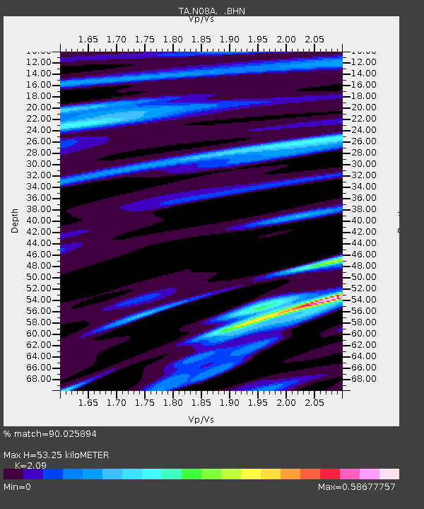
| Estimated Moho Depth: |
53.25 km |
| Estimated Crust Vp/Vs: |
2.09 |
| Assumed Crust Vp: |
6.276 km/s |
| Estimated Crust Vs: |
3.003 km/s |
| Estimated Crust Poisson's Ratio: |
0.35 |
|
| Radial Match: |
90.025894 % |
| Radial Bump: |
310 |
| Transverse Match: |
65.82067 % |
| Transverse Bump: |
400 |
| SOD ConfigId: |
2564 |
| Insert Time: |
2010-03-07 01:10:57.311 +0000 |
| GWidth: |
2.5 |
| Max Bumps: |
400 |
| Tol: |
0.001 |
|

Signal To Noise
| Channel | StoN | STA | LTA |
| TA:N08A: :BHN:20071127T12:02:22.325002Z | 2.3749309 | 2.2592994E-7 | 9.513116E-8 |
| TA:N08A: :BHE:20071127T12:02:22.325002Z | 3.9157338 | 3.7947333E-7 | 9.690989E-8 |
| TA:N08A: :BHZ:20071127T12:02:22.325002Z | 10.410075 | 1.2197597E-6 | 1.1717108E-7 |
| Arrivals |
| Ps | 9.4 SECOND |
| PpPs | 26 SECOND |
| PsPs/PpSs | 35 SECOND |


