You are here: Home > Network List > TA - USArray Transportable Network (new EarthScope stations) Stations List
> Station N08A GE Springer Mine, Mill City, NV, USA > Earthquake Result Viewer
N08A GE Springer Mine, Mill City, NV, USA - Earthquake Result Viewer
| Earthquake location: |
Peru-Ecuador Border Region |
| Earthquake latitude/longitude: |
-2.3/-77.8 |
| Earthquake time(UTC): |
2007/11/16 (320) 03:13:00 GMT |
| Earthquake Depth: |
123 km |
| Earthquake Magnitude: |
6.3 MB, 6.8 MW, 6.7 MW |
| Earthquake Catalog/Contributor: |
WHDF/NEIC |
|
| Network: |
TA USArray Transportable Network (new EarthScope stations) |
| Station: |
N08A GE Springer Mine, Mill City, NV, USA |
| Lat/Lon: |
40.78 N/118.13 W |
| Elevation: |
1493 m |
|
| Distance: |
56.5 deg |
| Az: |
323.894 deg |
| Baz: |
129.16 deg |
| Ray Param: |
0.06375012 |
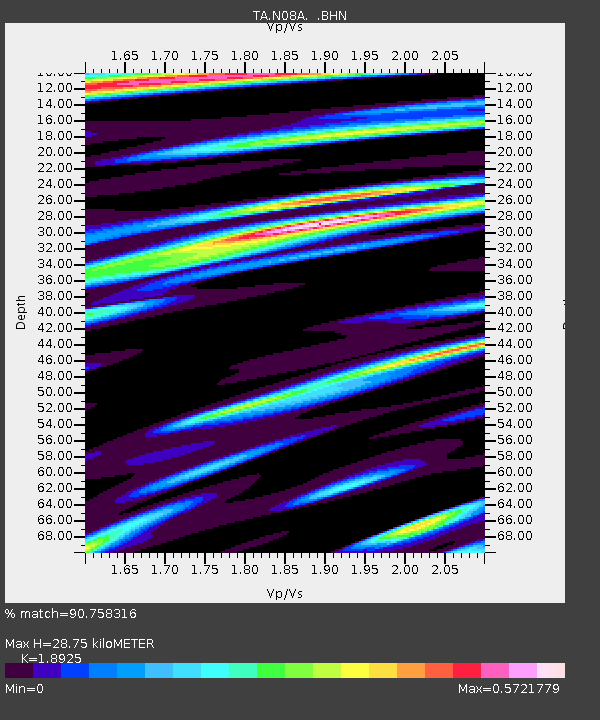
| Estimated Moho Depth: |
28.75 km |
| Estimated Crust Vp/Vs: |
1.89 |
| Assumed Crust Vp: |
6.276 km/s |
| Estimated Crust Vs: |
3.316 km/s |
| Estimated Crust Poisson's Ratio: |
0.31 |
|
| Radial Match: |
90.758316 % |
| Radial Bump: |
400 |
| Transverse Match: |
78.227554 % |
| Transverse Bump: |
400 |
| SOD ConfigId: |
2564 |
| Insert Time: |
2010-03-07 01:10:58.952 +0000 |
| GWidth: |
2.5 |
| Max Bumps: |
400 |
| Tol: |
0.001 |
|

Signal To Noise
| Channel | StoN | STA | LTA |
| TA:N08A: :BHN:20071116T03:21:58.450017Z | 2.1179006 | 6.053353E-7 | 2.8581852E-7 |
| TA:N08A: :BHE:20071116T03:21:58.450017Z | 1.7589457 | 2.0041882E-7 | 1.1394258E-7 |
| TA:N08A: :BHZ:20071116T03:21:58.450017Z | 2.5219145 | 7.126583E-7 | 2.8258623E-7 |
| Arrivals |
| Ps | 4.3 SECOND |
| PpPs | 13 SECOND |
| PsPs/PpSs | 17 SECOND |


