You are here: Home > Network List > TA - USArray Transportable Network (new EarthScope stations) Stations List
> Station N08A GE Springer Mine, Mill City, NV, USA > Earthquake Result Viewer
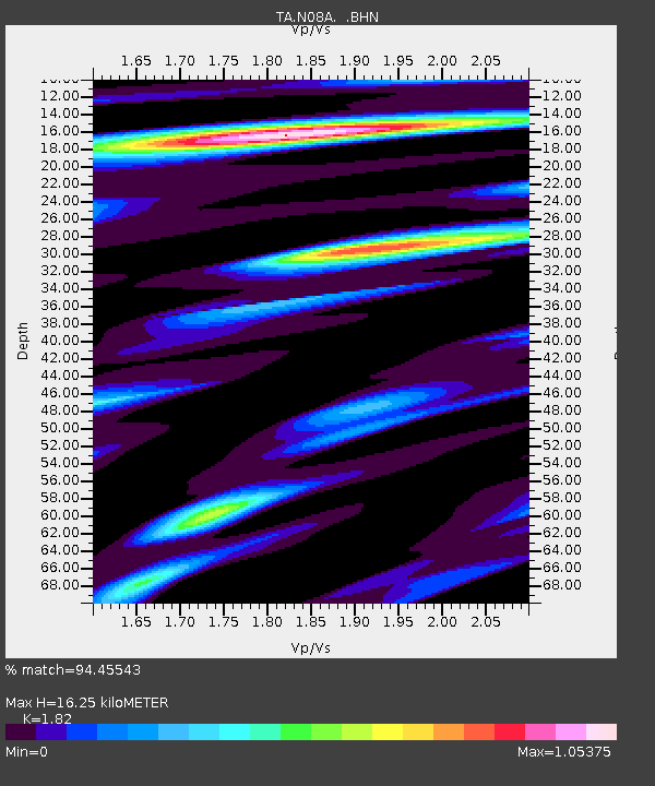
N08A GE Springer Mine, Mill City, NV, USA - Earthquake Result Viewer
| Earthquake location: |
Mariana Islands |
| Earthquake latitude/longitude: |
18.9/145.4 |
| Earthquake time(UTC): |
2007/10/31 (304) 03:30:17 GMT |
| Earthquake Depth: |
223 km |
| Earthquake Magnitude: |
6.2 MB, 7.2 MW, 7.2 MW |
| Earthquake Catalog/Contributor: |
WHDF/NEIC |
|
| Network: |
TA USArray Transportable Network (new EarthScope stations) |
| Station: |
N08A GE Springer Mine, Mill City, NV, USA |
| Lat/Lon: |
40.78 N/118.13 W |
| Elevation: |
1493 m |
|
| Distance: |
82.6 deg |
| Az: |
49.53 deg |
| Baz: |
288.471 deg |
| Ray Param: |
0.046194267 |
| Estimated Moho Depth: |
16.25 km |
| Estimated Crust Vp/Vs: |
1.82 |
| Assumed Crust Vp: |
6.276 km/s |
| Estimated Crust Vs: |
3.448 km/s |
| Estimated Crust Poisson's Ratio: |
0.28 |
|
| Radial Match: |
94.45543 % |
| Radial Bump: |
400 |
| Transverse Match: |
70.725975 % |
| Transverse Bump: |
400 |
| SOD ConfigId: |
2564 |
| Insert Time: |
2010-03-07 01:11:04.040 +0000 |
| GWidth: |
2.5 |
| Max Bumps: |
400 |
| Tol: |
0.001 |
|

Signal To Noise
| Channel | StoN | STA | LTA |
| TA:N08A: :BHN:20071031T03:41:44.699001Z | 1.5210948 | 4.4087943E-7 | 2.898435E-7 |
| TA:N08A: :BHE:20071031T03:41:44.699001Z | 5.285065 | 1.302472E-6 | 2.4644388E-7 |
| TA:N08A: :BHZ:20071031T03:41:44.699001Z | 28.442884 | 4.0558375E-6 | 1.4259585E-7 |
| Arrivals |
| Ps | 2.2 SECOND |
| PpPs | 7.1 SECOND |
| PsPs/PpSs | 9.3 SECOND |


