You are here: Home > Network List > TA - USArray Transportable Network (new EarthScope stations) Stations List
> Station N08A GE Springer Mine, Mill City, NV, USA > Earthquake Result Viewer
N08A GE Springer Mine, Mill City, NV, USA - Earthquake Result Viewer
| Earthquake location: |
Near West Coast Of Colombia |
| Earthquake latitude/longitude: |
3.0/-78.0 |
| Earthquake time(UTC): |
2007/09/10 (253) 01:49:14 GMT |
| Earthquake Depth: |
31 km |
| Earthquake Magnitude: |
6.1 MB, 6.7 MS, 6.8 MW |
| Earthquake Catalog/Contributor: |
WHDF/NEIC |
|
| Network: |
TA USArray Transportable Network (new EarthScope stations) |
| Station: |
N08A GE Springer Mine, Mill City, NV, USA |
| Lat/Lon: |
40.78 N/118.13 W |
| Elevation: |
1493 m |
|
| Distance: |
52.2 deg |
| Az: |
321.682 deg |
| Baz: |
125.372 deg |
| Ray Param: |
0.06686736 |
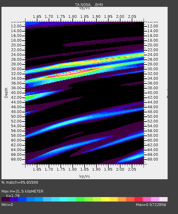
| Estimated Moho Depth: |
31.5 km |
| Estimated Crust Vp/Vs: |
1.79 |
| Assumed Crust Vp: |
6.276 km/s |
| Estimated Crust Vs: |
3.506 km/s |
| Estimated Crust Poisson's Ratio: |
0.27 |
|
| Radial Match: |
95.65598 % |
| Radial Bump: |
202 |
| Transverse Match: |
87.573524 % |
| Transverse Bump: |
354 |
| SOD ConfigId: |
2564 |
| Insert Time: |
2010-03-07 01:11:16.286 +0000 |
| GWidth: |
2.5 |
| Max Bumps: |
400 |
| Tol: |
0.001 |
|
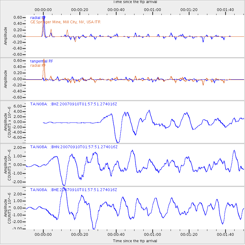
Signal To Noise
| Channel | StoN | STA | LTA |
| TA:N08A: :BHN:20070910T01:57:51.274016Z | 3.9863925 | 3.795029E-7 | 9.519958E-8 |
| TA:N08A: :BHE:20070910T01:57:51.274016Z | 5.2263684 | 5.105127E-7 | 9.768019E-8 |
| TA:N08A: :BHZ:20070910T01:57:51.274016Z | 14.130566 | 1.2665765E-6 | 8.9633815E-8 |
| Arrivals |
| Ps | 4.2 SECOND |
| PpPs | 13 SECOND |
| PsPs/PpSs | 17 SECOND |


