You are here: Home > Network List > TA - USArray Transportable Network (new EarthScope stations) Stations List
> Station N08A GE Springer Mine, Mill City, NV, USA > Earthquake Result Viewer
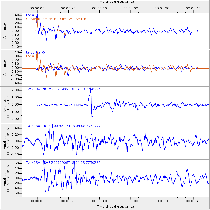
N08A GE Springer Mine, Mill City, NV, USA - Earthquake Result Viewer

| Earthquake location: |
Taiwan Region |
| Earthquake latitude/longitude: |
24.3/122.2 |
| Earthquake time(UTC): |
2007/09/06 (249) 17:51:26 GMT |
| Earthquake Depth: |
53 km |
| Earthquake Magnitude: |
6.1 MB, 6.2 MW, 6.1 ME |
| Earthquake Catalog/Contributor: |
WHDF/NEIC |
|
| Network: |
TA USArray Transportable Network (new EarthScope stations) |
| Station: |
N08A GE Springer Mine, Mill City, NV, USA |
| Lat/Lon: |
40.78 N/118.13 W |
| Elevation: |
1493 m |
|
| Distance: |
94.4 deg |
| Az: |
41.443 deg |
| Baz: |
307.341 deg |
| Ray Param: |
0.041035175 |
| Estimated Moho Depth: |
24.5 km |
| Estimated Crust Vp/Vs: |
1.60 |
| Assumed Crust Vp: |
6.276 km/s |
| Estimated Crust Vs: |
3.922 km/s |
| Estimated Crust Poisson's Ratio: |
0.18 |
|
| Radial Match: |
85.302444 % |
| Radial Bump: |
400 |
| Transverse Match: |
65.1031 % |
| Transverse Bump: |
400 |
| SOD ConfigId: |
2564 |
| Insert Time: |
2010-03-07 01:11:18.818 +0000 |
| GWidth: |
2.5 |
| Max Bumps: |
400 |
| Tol: |
0.001 |
|
Signal To Noise
| Channel | StoN | STA | LTA |
| TA:N08A: :BHN:20070906T18:04:08.775022Z | 1.9333103 | 1.6661099E-7 | 8.617913E-8 |
| TA:N08A: :BHE:20070906T18:04:08.775022Z | 2.9471202 | 2.6385788E-7 | 8.953075E-8 |
| TA:N08A: :BHZ:20070906T18:04:08.775022Z | 16.144253 | 8.839412E-7 | 5.475269E-8 |
| Arrivals |
| Ps | 2.4 SECOND |
| PpPs | 9.9 SECOND |
| PsPs/PpSs | 12 SECOND |


