You are here: Home > Network List > TA - USArray Transportable Network (new EarthScope stations) Stations List
> Station N08A GE Springer Mine, Mill City, NV, USA > Earthquake Result Viewer
N08A GE Springer Mine, Mill City, NV, USA - Earthquake Result Viewer
| Earthquake location: |
Sakhalin, Russia |
| Earthquake latitude/longitude: |
47.1/141.8 |
| Earthquake time(UTC): |
2007/08/02 (214) 02:37:42 GMT |
| Earthquake Depth: |
5.0 km |
| Earthquake Magnitude: |
6.2 MS, 5.3 MB, 6.2 MW, 6.2 MW |
| Earthquake Catalog/Contributor: |
WHDF/NEIC |
|
| Network: |
TA USArray Transportable Network (new EarthScope stations) |
| Station: |
N08A GE Springer Mine, Mill City, NV, USA |
| Lat/Lon: |
40.78 N/118.13 W |
| Elevation: |
1493 m |
|
| Distance: |
67.4 deg |
| Az: |
54.094 deg |
| Baz: |
313.241 deg |
| Ray Param: |
0.05700387 |
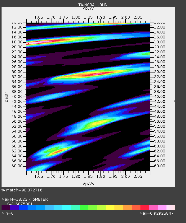
| Estimated Moho Depth: |
18.25 km |
| Estimated Crust Vp/Vs: |
1.61 |
| Assumed Crust Vp: |
6.276 km/s |
| Estimated Crust Vs: |
3.904 km/s |
| Estimated Crust Poisson's Ratio: |
0.18 |
|
| Radial Match: |
90.072716 % |
| Radial Bump: |
400 |
| Transverse Match: |
84.57138 % |
| Transverse Bump: |
400 |
| SOD ConfigId: |
2564 |
| Insert Time: |
2010-03-07 01:11:33.134 +0000 |
| GWidth: |
2.5 |
| Max Bumps: |
400 |
| Tol: |
0.001 |
|
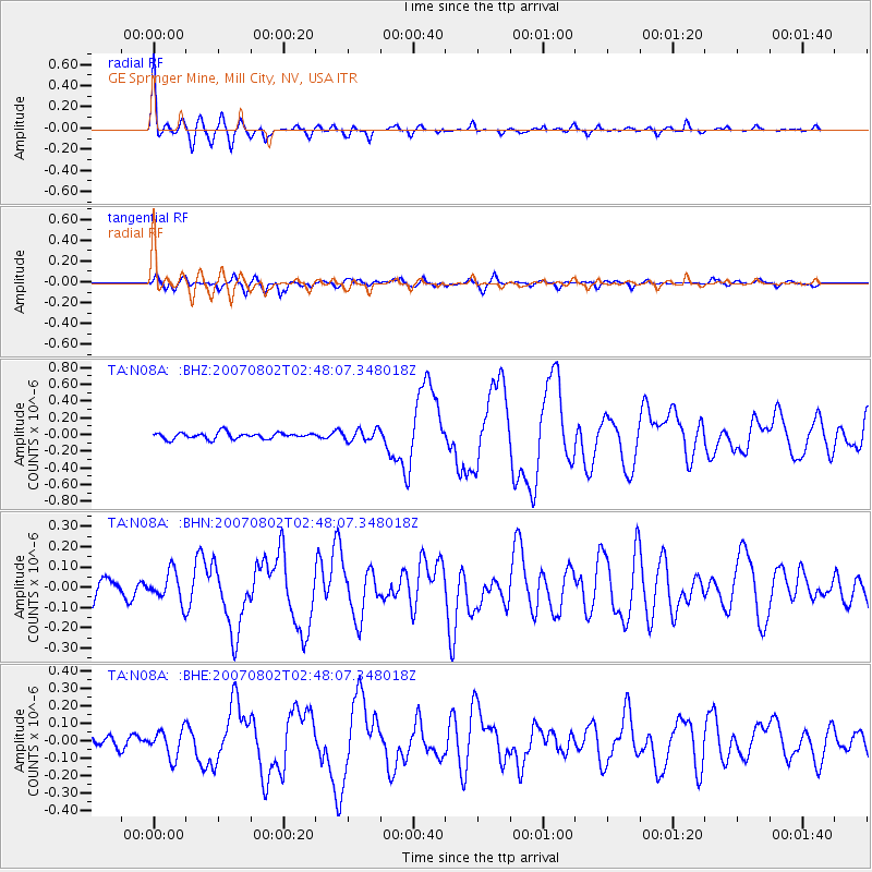
Signal To Noise
| Channel | StoN | STA | LTA |
| TA:N08A: :BHN:20070802T02:48:07.348018Z | 1.7421187 | 7.333733E-8 | 4.209663E-8 |
| TA:N08A: :BHE:20070802T02:48:07.348018Z | 2.0664928 | 7.69339E-8 | 3.722921E-8 |
| TA:N08A: :BHZ:20070802T02:48:07.348018Z | 1.8177963 | 6.8640524E-8 | 3.7760294E-8 |
| Arrivals |
| Ps | 1.8 SECOND |
| PpPs | 7.3 SECOND |
| PsPs/PpSs | 9.1 SECOND |


