You are here: Home > Network List > TA - USArray Transportable Network (new EarthScope stations) Stations List
> Station N08A GE Springer Mine, Mill City, NV, USA > Earthquake Result Viewer
N08A GE Springer Mine, Mill City, NV, USA - Earthquake Result Viewer
| Earthquake location: |
Kuril Islands |
| Earthquake latitude/longitude: |
46.9/153.7 |
| Earthquake time(UTC): |
2006/11/15 (319) 11:33:23 GMT |
| Earthquake Depth: |
10 km |
| Earthquake Magnitude: |
5.5 MB |
| Earthquake Catalog/Contributor: |
WHDF/NEIC |
|
| Network: |
TA USArray Transportable Network (new EarthScope stations) |
| Station: |
N08A GE Springer Mine, Mill City, NV, USA |
| Lat/Lon: |
40.78 N/118.13 W |
| Elevation: |
1493 m |
|
| Distance: |
60.6 deg |
| Az: |
60.552 deg |
| Baz: |
308.104 deg |
| Ray Param: |
0.061396882 |
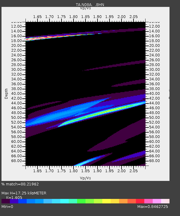
| Estimated Moho Depth: |
17.25 km |
| Estimated Crust Vp/Vs: |
1.61 |
| Assumed Crust Vp: |
6.276 km/s |
| Estimated Crust Vs: |
3.91 km/s |
| Estimated Crust Poisson's Ratio: |
0.18 |
|
| Radial Match: |
88.21962 % |
| Radial Bump: |
400 |
| Transverse Match: |
81.86224 % |
| Transverse Bump: |
399 |
| SOD ConfigId: |
2564 |
| Insert Time: |
2010-03-07 01:11:57.379 +0000 |
| GWidth: |
2.5 |
| Max Bumps: |
400 |
| Tol: |
0.001 |
|
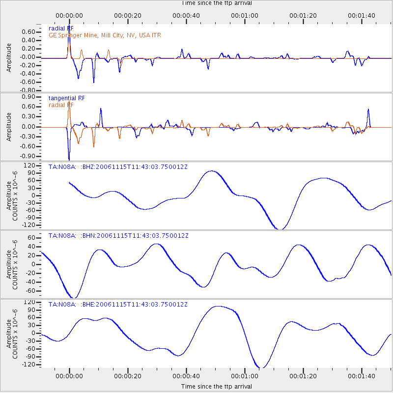
Signal To Noise
| Channel | StoN | STA | LTA |
| TA:N08A: :BHN:20061115T11:43:03.750012Z | 6.514122 | 7.724097E-5 | 1.18574635E-5 |
| TA:N08A: :BHE:20061115T11:43:03.750012Z | 3.634772 | 5.3603126E-5 | 1.4747315E-5 |
| TA:N08A: :BHZ:20061115T11:43:03.750012Z | 1.2785652 | 3.0723077E-5 | 2.4029338E-5 |
| Arrivals |
| Ps | 1.7 SECOND |
| PpPs | 6.8 SECOND |
| PsPs/PpSs | 8.6 SECOND |


