You are here: Home > Network List > TA - USArray Transportable Network (new EarthScope stations) Stations List
> Station N08A GE Springer Mine, Mill City, NV, USA > Earthquake Result Viewer
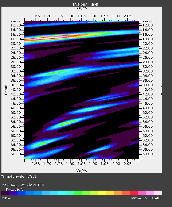
N08A GE Springer Mine, Mill City, NV, USA - Earthquake Result Viewer
| Earthquake location: |
Near East Coast Of Kamchatka |
| Earthquake latitude/longitude: |
55.6/161.7 |
| Earthquake time(UTC): |
2006/08/17 (229) 11:11:35 GMT |
| Earthquake Depth: |
55 km |
| Earthquake Magnitude: |
6.1 MB, 5.7 MW, 5.7 MW |
| Earthquake Catalog/Contributor: |
WHDF/NEIC |
|
| Network: |
TA USArray Transportable Network (new EarthScope stations) |
| Station: |
N08A GE Springer Mine, Mill City, NV, USA |
| Lat/Lon: |
40.78 N/118.13 W |
| Elevation: |
1493 m |
|
| Distance: |
52.5 deg |
| Az: |
70.67 deg |
| Baz: |
315.174 deg |
| Ray Param: |
0.06660389 |
| Estimated Moho Depth: |
17.25 km |
| Estimated Crust Vp/Vs: |
1.70 |
| Assumed Crust Vp: |
6.276 km/s |
| Estimated Crust Vs: |
3.697 km/s |
| Estimated Crust Poisson's Ratio: |
0.23 |
|
| Radial Match: |
86.47361 % |
| Radial Bump: |
400 |
| Transverse Match: |
74.313545 % |
| Transverse Bump: |
400 |
| SOD ConfigId: |
2564 |
| Insert Time: |
2010-03-07 01:12:00.949 +0000 |
| GWidth: |
2.5 |
| Max Bumps: |
400 |
| Tol: |
0.001 |
|

Signal To Noise
| Channel | StoN | STA | LTA |
| TA:N08A: :BHN:20060817T11:20:12.17501Z | 6.244051 | 3.4043126E-7 | 5.4520896E-8 |
| TA:N08A: :BHE:20060817T11:20:12.17501Z | 6.018422 | 3.0198024E-7 | 5.0175984E-8 |
| TA:N08A: :BHZ:20060817T11:20:12.17501Z | 11.232144 | 8.1296E-7 | 7.237799E-8 |
| Arrivals |
| Ps | 2.0 SECOND |
| PpPs | 7.0 SECOND |
| PsPs/PpSs | 9.0 SECOND |


