You are here: Home > Network List > TA - USArray Transportable Network (new EarthScope stations) Stations List
> Station N08A GE Springer Mine, Mill City, NV, USA > Earthquake Result Viewer
N08A GE Springer Mine, Mill City, NV, USA - Earthquake Result Viewer
| Earthquake location: |
New Britain Region, P.N.G. |
| Earthquake latitude/longitude: |
-5.9/151.0 |
| Earthquake time(UTC): |
2006/10/17 (290) 01:25:12 GMT |
| Earthquake Depth: |
32 km |
| Earthquake Magnitude: |
6.4 MB, 6.9 MS, 6.7 MW, 6.6 MW |
| Earthquake Catalog/Contributor: |
WHDF/NEIC |
|
| Network: |
TA USArray Transportable Network (new EarthScope stations) |
| Station: |
N08A GE Springer Mine, Mill City, NV, USA |
| Lat/Lon: |
40.78 N/118.13 W |
| Elevation: |
1493 m |
|
| Distance: |
94.5 deg |
| Az: |
49.605 deg |
| Baz: |
266.129 deg |
| Ray Param: |
0.041024473 |
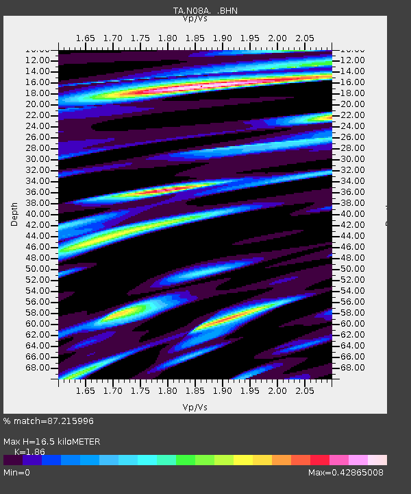
| Estimated Moho Depth: |
16.5 km |
| Estimated Crust Vp/Vs: |
1.86 |
| Assumed Crust Vp: |
6.276 km/s |
| Estimated Crust Vs: |
3.374 km/s |
| Estimated Crust Poisson's Ratio: |
0.30 |
|
| Radial Match: |
87.215996 % |
| Radial Bump: |
400 |
| Transverse Match: |
78.62102 % |
| Transverse Bump: |
400 |
| SOD ConfigId: |
2665 |
| Insert Time: |
2010-03-07 01:12:03.745 +0000 |
| GWidth: |
2.5 |
| Max Bumps: |
400 |
| Tol: |
0.001 |
|
Signal To Noise
| Channel | StoN | STA | LTA |
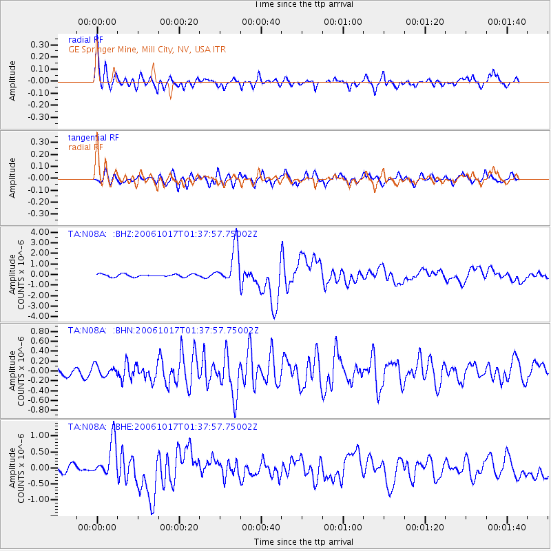
| TA:N08A: :BHN:20061017T01:37:57.75002Z | 1.0978277 | 1.0610769E-7 | 9.6652414E-8 |
| TA:N08A: :BHE:20061017T01:37:57.75002Z | 4.0253716 | 5.881886E-7 | 1.4612033E-7 |
| TA:N08A: :BHZ:20061017T01:37:57.75002Z | 14.925506 | 1.7973971E-6 | 1.2042453E-7 |
| Arrivals |
| Ps | 2.3 SECOND |
| PpPs | 7.4 SECOND |
| PsPs/PpSs | 9.7 SECOND |


