You are here: Home > Network List > TA - USArray Transportable Network (new EarthScope stations) Stations List
> Station N08A GE Springer Mine, Mill City, NV, USA > Earthquake Result Viewer
N08A GE Springer Mine, Mill City, NV, USA - Earthquake Result Viewer
| Earthquake location: |
San Juan Province, Argentina |
| Earthquake latitude/longitude: |
-31.7/-67.2 |
| Earthquake time(UTC): |
2006/09/17 (260) 09:34:14 GMT |
| Earthquake Depth: |
142 km |
| Earthquake Magnitude: |
5.7 MB, 6.2 MW, 6.2 MW |
| Earthquake Catalog/Contributor: |
WHDF/NEIC |
|
| Network: |
TA USArray Transportable Network (new EarthScope stations) |
| Station: |
N08A GE Springer Mine, Mill City, NV, USA |
| Lat/Lon: |
40.78 N/118.13 W |
| Elevation: |
1493 m |
|
| Distance: |
86.2 deg |
| Az: |
323.764 deg |
| Baz: |
138.456 deg |
| Ray Param: |
0.04393027 |
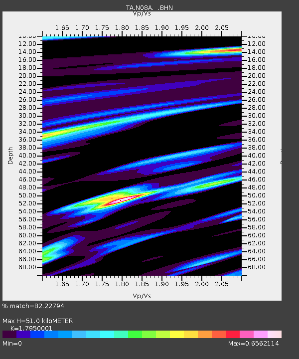
| Estimated Moho Depth: |
51.0 km |
| Estimated Crust Vp/Vs: |
1.80 |
| Assumed Crust Vp: |
6.276 km/s |
| Estimated Crust Vs: |
3.496 km/s |
| Estimated Crust Poisson's Ratio: |
0.27 |
|
| Radial Match: |
82.22794 % |
| Radial Bump: |
400 |
| Transverse Match: |
65.61986 % |
| Transverse Bump: |
400 |
| SOD ConfigId: |
2665 |
| Insert Time: |
2010-03-07 01:12:18.072 +0000 |
| GWidth: |
2.5 |
| Max Bumps: |
400 |
| Tol: |
0.001 |
|

Signal To Noise
| Channel | StoN | STA | LTA |
| TA:N08A: :BHN:20060917T09:46:08.125002Z | 3.55418 | 2.0180278E-7 | 5.6779E-8 |
| TA:N08A: :BHE:20060917T09:46:08.125002Z | 3.1476872 | 1.6807977E-7 | 5.3397862E-8 |
| TA:N08A: :BHZ:20060917T09:46:08.125002Z | 14.351725 | 8.5065403E-7 | 5.9271905E-8 |
| Arrivals |
| Ps | 6.6 SECOND |
| PpPs | 22 SECOND |
| PsPs/PpSs | 29 SECOND |


