You are here: Home > Network List > TA - USArray Transportable Network (new EarthScope stations) Stations List
> Station N08A GE Springer Mine, Mill City, NV, USA > Earthquake Result Viewer
N08A GE Springer Mine, Mill City, NV, USA - Earthquake Result Viewer
| Earthquake location: |
Off Coast Of Chiapas, Mexico |
| Earthquake latitude/longitude: |
15.0/-94.2 |
| Earthquake time(UTC): |
2006/06/27 (178) 13:03:12 GMT |
| Earthquake Depth: |
29 km |
| Earthquake Magnitude: |
5.4 MB, 5.5 MS, 5.8 MW, 5.8 MW |
| Earthquake Catalog/Contributor: |
WHDF/NEIC |
|
| Network: |
TA USArray Transportable Network (new EarthScope stations) |
| Station: |
N08A GE Springer Mine, Mill City, NV, USA |
| Lat/Lon: |
40.78 N/118.13 W |
| Elevation: |
1493 m |
|
| Distance: |
33.1 deg |
| Az: |
325.635 deg |
| Baz: |
134.073 deg |
| Ray Param: |
0.07831725 |
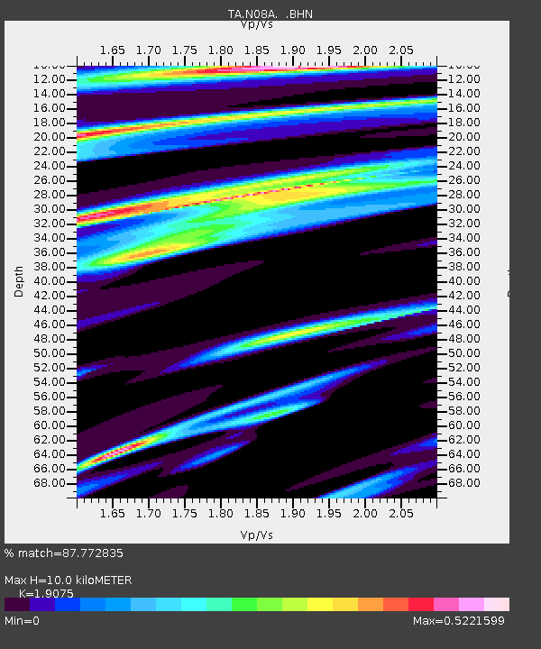
| Estimated Moho Depth: |
10.0 km |
| Estimated Crust Vp/Vs: |
1.91 |
| Assumed Crust Vp: |
6.276 km/s |
| Estimated Crust Vs: |
3.29 km/s |
| Estimated Crust Poisson's Ratio: |
0.31 |
|
| Radial Match: |
87.772835 % |
| Radial Bump: |
284 |
| Transverse Match: |
64.41327 % |
| Transverse Bump: |
400 |
| SOD ConfigId: |
2665 |
| Insert Time: |
2010-03-07 01:12:32.909 +0000 |
| GWidth: |
2.5 |
| Max Bumps: |
400 |
| Tol: |
0.001 |
|
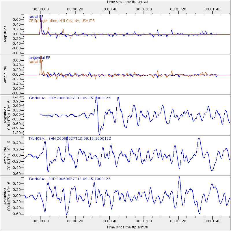
Signal To Noise
| Channel | StoN | STA | LTA |
| TA:N08A: :BHN:20060627T13:09:15.100012Z | 7.368187 | 2.9812438E-7 | 4.046102E-8 |
| TA:N08A: :BHE:20060627T13:09:15.100012Z | 7.848154 | 2.9912675E-7 | 3.811428E-8 |
| TA:N08A: :BHZ:20060627T13:09:15.100012Z | 14.438089 | 7.4960286E-7 | 5.1918427E-8 |
| Arrivals |
| Ps | 1.5 SECOND |
| PpPs | 4.3 SECOND |
| PsPs/PpSs | 5.9 SECOND |


