You are here: Home > Network List > TA - USArray Transportable Network (new EarthScope stations) Stations List
> Station N08A GE Springer Mine, Mill City, NV, USA > Earthquake Result Viewer
N08A GE Springer Mine, Mill City, NV, USA - Earthquake Result Viewer
| Earthquake location: |
Mongolia |
| Earthquake latitude/longitude: |
45.4/97.4 |
| Earthquake time(UTC): |
2006/06/15 (166) 06:49:48 GMT |
| Earthquake Depth: |
9.0 km |
| Earthquake Magnitude: |
5.7 MB, 5.6 MS, 5.8 MW, 5.8 MW |
| Earthquake Catalog/Contributor: |
WHDF/NEIC |
|
| Network: |
TA USArray Transportable Network (new EarthScope stations) |
| Station: |
N08A GE Springer Mine, Mill City, NV, USA |
| Lat/Lon: |
40.78 N/118.13 W |
| Elevation: |
1493 m |
|
| Distance: |
88.5 deg |
| Az: |
26.167 deg |
| Baz: |
335.844 deg |
| Ray Param: |
0.042532377 |
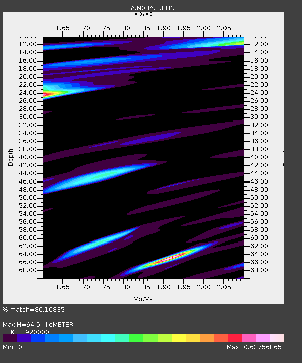
| Estimated Moho Depth: |
64.5 km |
| Estimated Crust Vp/Vs: |
1.92 |
| Assumed Crust Vp: |
6.276 km/s |
| Estimated Crust Vs: |
3.269 km/s |
| Estimated Crust Poisson's Ratio: |
0.31 |
|
| Radial Match: |
80.10835 % |
| Radial Bump: |
400 |
| Transverse Match: |
75.08294 % |
| Transverse Bump: |
360 |
| SOD ConfigId: |
5745 |
| Insert Time: |
2010-03-07 01:12:35.981 +0000 |
| GWidth: |
2.5 |
| Max Bumps: |
400 |
| Tol: |
0.001 |
|
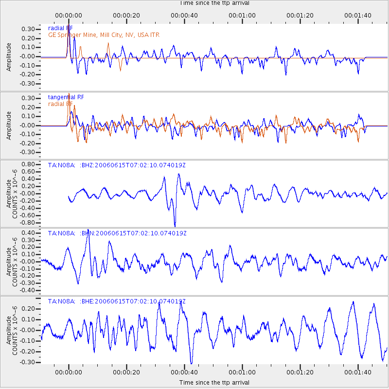
Signal To Noise
| Channel | StoN | STA | LTA |
| TA:N08A: :BHN:20060615T07:02:10.074019Z | 2.669945 | 1.5507491E-7 | 5.808169E-8 |
| TA:N08A: :BHE:20060615T07:02:10.074019Z | 0.9907916 | 6.078702E-8 | 6.1351976E-8 |
| TA:N08A: :BHZ:20060615T07:02:10.074019Z | 2.5438366 | 2.3317881E-7 | 9.166422E-8 |
| Arrivals |
| Ps | 9.6 SECOND |
| PpPs | 29 SECOND |
| PsPs/PpSs | 39 SECOND |


