You are here: Home > Network List > TA - USArray Transportable Network (new EarthScope stations) Stations List
> Station N08A GE Springer Mine, Mill City, NV, USA > Earthquake Result Viewer
N08A GE Springer Mine, Mill City, NV, USA - Earthquake Result Viewer
| Earthquake location: |
Rat Islands, Aleutian Islands |
| Earthquake latitude/longitude: |
51.8/177.1 |
| Earthquake time(UTC): |
2006/06/14 (165) 04:18:42 GMT |
| Earthquake Depth: |
14 km |
| Earthquake Magnitude: |
5.9 MB, 6.4 MS, 6.4 MW, 6.4 MW |
| Earthquake Catalog/Contributor: |
WHDF/NEIC |
|
| Network: |
TA USArray Transportable Network (new EarthScope stations) |
| Station: |
N08A GE Springer Mine, Mill City, NV, USA |
| Lat/Lon: |
40.78 N/118.13 W |
| Elevation: |
1493 m |
|
| Distance: |
44.7 deg |
| Az: |
77.6 deg |
| Baz: |
306.917 deg |
| Ray Param: |
0.07174364 |
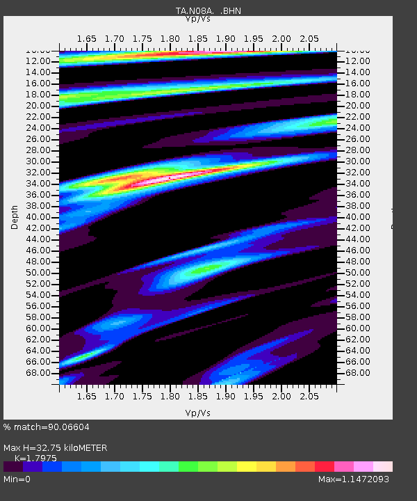
| Estimated Moho Depth: |
32.75 km |
| Estimated Crust Vp/Vs: |
1.80 |
| Assumed Crust Vp: |
6.276 km/s |
| Estimated Crust Vs: |
3.491 km/s |
| Estimated Crust Poisson's Ratio: |
0.28 |
|
| Radial Match: |
90.06604 % |
| Radial Bump: |
400 |
| Transverse Match: |
73.06223 % |
| Transverse Bump: |
400 |
| SOD ConfigId: |
5745 |
| Insert Time: |
2010-03-07 01:12:39.621 +0000 |
| GWidth: |
2.5 |
| Max Bumps: |
400 |
| Tol: |
0.001 |
|

Signal To Noise
| Channel | StoN | STA | LTA |
| TA:N08A: :BHN:20060614T04:26:24.075002Z | 2.235405 | 1.7963765E-7 | 8.036023E-8 |
| TA:N08A: :BHE:20060614T04:26:24.075002Z | 2.7948198 | 1.6158077E-7 | 5.781438E-8 |
| TA:N08A: :BHZ:20060614T04:26:24.075002Z | 6.746969 | 4.198831E-7 | 6.223284E-8 |
| Arrivals |
| Ps | 4.4 SECOND |
| PpPs | 14 SECOND |
| PsPs/PpSs | 18 SECOND |


