You are here: Home > Network List > US - United States National Seismic Network Stations List
> Station CBKS Cedar Bluff, Kansas, USA > Earthquake Result Viewer
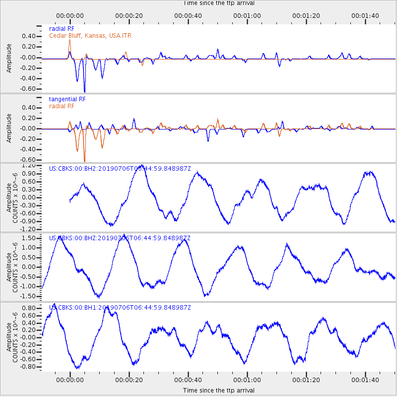
CBKS Cedar Bluff, Kansas, USA - Earthquake Result Viewer
*The percent match for this event was below the threshold and hence no stack was calculated.
| Earthquake location: |
Kermadec Islands Region |
| Earthquake latitude/longitude: |
-27.7/-176.2 |
| Earthquake time(UTC): |
2019/07/06 (187) 06:31:58 GMT |
| Earthquake Depth: |
10 km |
| Earthquake Magnitude: |
5.5 mb |
| Earthquake Catalog/Contributor: |
NEIC PDE/us |
|
| Network: |
US United States National Seismic Network |
| Station: |
CBKS Cedar Bluff, Kansas, USA |
| Lat/Lon: |
38.81 N/99.74 W |
| Elevation: |
677 m |
|
| Distance: |
97.3 deg |
| Az: |
49.981 deg |
| Baz: |
240.372 deg |
| Ray Param: |
$rayparam |
*The percent match for this event was below the threshold and hence was not used in the summary stack. |
|
| Radial Match: |
93.22084 % |
| Radial Bump: |
327 |
| Transverse Match: |
71.89087 % |
| Transverse Bump: |
400 |
| SOD ConfigId: |
19053131 |
| Insert Time: |
2019-07-20 06:38:16.008 +0000 |
| GWidth: |
2.5 |
| Max Bumps: |
400 |
| Tol: |
0.001 |
|
Signal To Noise
| Channel | StoN | STA | LTA |
| US:CBKS:00:BHZ:20190706T06:44:59.848987Z | 0.6555474 | 5.7043667E-7 | 8.7016844E-7 |
| US:CBKS:00:BH1:20190706T06:44:59.848987Z | 1.5807114 | 6.9839604E-7 | 4.418239E-7 |
| US:CBKS:00:BH2:20190706T06:44:59.848987Z | 0.83679605 | 5.34654E-7 | 6.389299E-7 |
| Arrivals |
| Ps | |
| PpPs | |
| PsPs/PpSs | |


