You are here: Home > Network List > TA - USArray Transportable Network (new EarthScope stations) Stations List
> Station N08A GE Springer Mine, Mill City, NV, USA > Earthquake Result Viewer
N08A GE Springer Mine, Mill City, NV, USA - Earthquake Result Viewer
| Earthquake location: |
Tonga Islands |
| Earthquake latitude/longitude: |
-20.2/-174.1 |
| Earthquake time(UTC): |
2006/05/03 (123) 15:26:40 GMT |
| Earthquake Depth: |
55 km |
| Earthquake Magnitude: |
7.2 MB, 7.8 MS, 7.9 MW, 7.9 MW |
| Earthquake Catalog/Contributor: |
WHDF/NEIC |
|
| Network: |
TA USArray Transportable Network (new EarthScope stations) |
| Station: |
N08A GE Springer Mine, Mill City, NV, USA |
| Lat/Lon: |
40.78 N/118.13 W |
| Elevation: |
1493 m |
|
| Distance: |
79.9 deg |
| Az: |
39.749 deg |
| Baz: |
232.274 deg |
| Ray Param: |
0.04855845 |
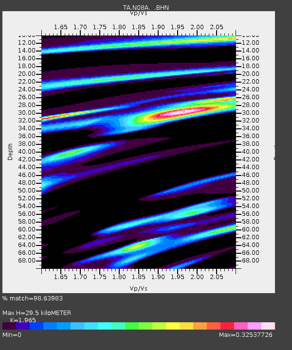
| Estimated Moho Depth: |
29.5 km |
| Estimated Crust Vp/Vs: |
1.97 |
| Assumed Crust Vp: |
6.276 km/s |
| Estimated Crust Vs: |
3.194 km/s |
| Estimated Crust Poisson's Ratio: |
0.33 |
|
| Radial Match: |
98.63983 % |
| Radial Bump: |
290 |
| Transverse Match: |
94.53877 % |
| Transverse Bump: |
400 |
| SOD ConfigId: |
2669 |
| Insert Time: |
2010-03-07 01:12:49.113 +0000 |
| GWidth: |
2.5 |
| Max Bumps: |
400 |
| Tol: |
0.001 |
|

Signal To Noise
| Channel | StoN | STA | LTA |
| TA:N08A: :BHN:20060503T15:38:12.05001Z | 2.7685676 | 3.302549E-7 | 1.1928728E-7 |
| TA:N08A: :BHE:20060503T15:38:12.05001Z | 3.8838155 | 5.2567714E-7 | 1.3535069E-7 |
| TA:N08A: :BHZ:20060503T15:38:12.05001Z | 4.761896 | 1.3539286E-6 | 2.8432552E-7 |
| Arrivals |
| Ps | 4.6 SECOND |
| PpPs | 14 SECOND |
| PsPs/PpSs | 18 SECOND |


