You are here: Home > Network List > TA - USArray Transportable Network (new EarthScope stations) Stations List
> Station O06A Flanigan, NV, USA > Earthquake Result Viewer
O06A Flanigan, NV, USA - Earthquake Result Viewer
| Earthquake location: |
Santa Cruz Islands |
| Earthquake latitude/longitude: |
-11.6/165.8 |
| Earthquake time(UTC): |
2007/09/02 (245) 01:05:18 GMT |
| Earthquake Depth: |
35 km |
| Earthquake Magnitude: |
5.9 MB, 7.3 MS, 7.2 MW, 6.9 ME |
| Earthquake Catalog/Contributor: |
WHDF/NEIC |
|
| Network: |
TA USArray Transportable Network (new EarthScope stations) |
| Station: |
O06A Flanigan, NV, USA |
| Lat/Lon: |
40.17 N/119.83 W |
| Elevation: |
1229 m |
|
| Distance: |
85.8 deg |
| Az: |
47.742 deg |
| Baz: |
251.139 deg |
| Ray Param: |
0.044461764 |
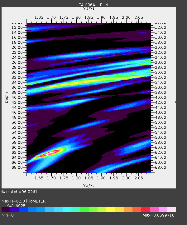
| Estimated Moho Depth: |
62.0 km |
| Estimated Crust Vp/Vs: |
1.69 |
| Assumed Crust Vp: |
6.276 km/s |
| Estimated Crust Vs: |
3.708 km/s |
| Estimated Crust Poisson's Ratio: |
0.23 |
|
| Radial Match: |
96.0261 % |
| Radial Bump: |
400 |
| Transverse Match: |
84.43183 % |
| Transverse Bump: |
400 |
| SOD ConfigId: |
2564 |
| Insert Time: |
2010-03-07 01:13:30.035 +0000 |
| GWidth: |
2.5 |
| Max Bumps: |
400 |
| Tol: |
0.001 |
|
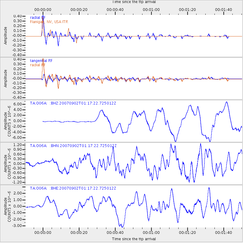
Signal To Noise
| Channel | StoN | STA | LTA |
| TA:O06A: :BHN:20070902T01:17:22.725012Z | 2.0994244 | 1.4520428E-7 | 6.916385E-8 |
| TA:O06A: :BHE:20070902T01:17:22.725012Z | 9.966116 | 9.812622E-7 | 9.845984E-8 |
| TA:O06A: :BHZ:20070902T01:17:22.725012Z | 26.413116 | 2.7330618E-6 | 1.0347366E-7 |
| Arrivals |
| Ps | 7.0 SECOND |
| PpPs | 26 SECOND |
| PsPs/PpSs | 33 SECOND |


