You are here: Home > Network List > TA - USArray Transportable Network (new EarthScope stations) Stations List
> Station G31M Satah River, YT, CAN > Earthquake Result Viewer
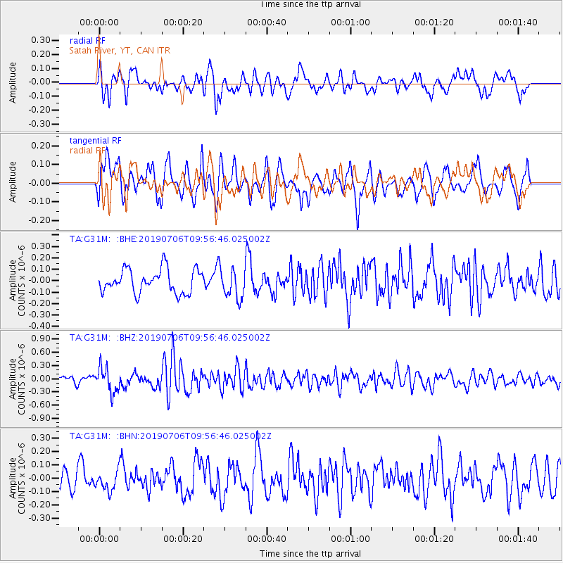
G31M Satah River, YT, CAN - Earthquake Result Viewer
*The percent match for this event was below the threshold and hence no stack was calculated.
| Earthquake location: |
Solomon Islands |
| Earthquake latitude/longitude: |
-6.3/154.7 |
| Earthquake time(UTC): |
2019/07/06 (187) 09:44:29 GMT |
| Earthquake Depth: |
43 km |
| Earthquake Magnitude: |
5.5 Mww |
| Earthquake Catalog/Contributor: |
NEIC PDE/us |
|
| Network: |
TA USArray Transportable Network (new EarthScope stations) |
| Station: |
G31M Satah River, YT, CAN |
| Lat/Lon: |
66.92 N/134.27 W |
| Elevation: |
61 m |
|
| Distance: |
88.4 deg |
| Az: |
21.894 deg |
| Baz: |
250.112 deg |
| Ray Param: |
$rayparam |
*The percent match for this event was below the threshold and hence was not used in the summary stack. |
|
| Radial Match: |
57.489826 % |
| Radial Bump: |
400 |
| Transverse Match: |
67.38496 % |
| Transverse Bump: |
400 |
| SOD ConfigId: |
19053131 |
| Insert Time: |
2019-07-20 09:51:16.000 +0000 |
| GWidth: |
2.5 |
| Max Bumps: |
400 |
| Tol: |
0.001 |
|
Signal To Noise
| Channel | StoN | STA | LTA |
| TA:G31M: :BHZ:20190706T09:56:46.025002Z | 3.4910645 | 2.855788E-7 | 8.180279E-8 |
| TA:G31M: :BHN:20190706T09:56:46.025002Z | 0.80623126 | 7.6349956E-8 | 9.4699814E-8 |
| TA:G31M: :BHE:20190706T09:56:46.025002Z | 1.1996237 | 1.2341978E-7 | 1.02882076E-7 |
| Arrivals |
| Ps | |
| PpPs | |
| PsPs/PpSs | |


