You are here: Home > Network List > TA - USArray Transportable Network (new EarthScope stations) Stations List
> Station O06A Flanigan, NV, USA > Earthquake Result Viewer
O06A Flanigan, NV, USA - Earthquake Result Viewer
| Earthquake location: |
Kuril Islands |
| Earthquake latitude/longitude: |
46.9/153.7 |
| Earthquake time(UTC): |
2006/11/15 (319) 11:33:23 GMT |
| Earthquake Depth: |
10 km |
| Earthquake Magnitude: |
5.5 MB |
| Earthquake Catalog/Contributor: |
WHDF/NEIC |
|
| Network: |
TA USArray Transportable Network (new EarthScope stations) |
| Station: |
O06A Flanigan, NV, USA |
| Lat/Lon: |
40.17 N/119.83 W |
| Elevation: |
1229 m |
|
| Distance: |
60.0 deg |
| Az: |
62.024 deg |
| Baz: |
307.738 deg |
| Ray Param: |
0.06181892 |
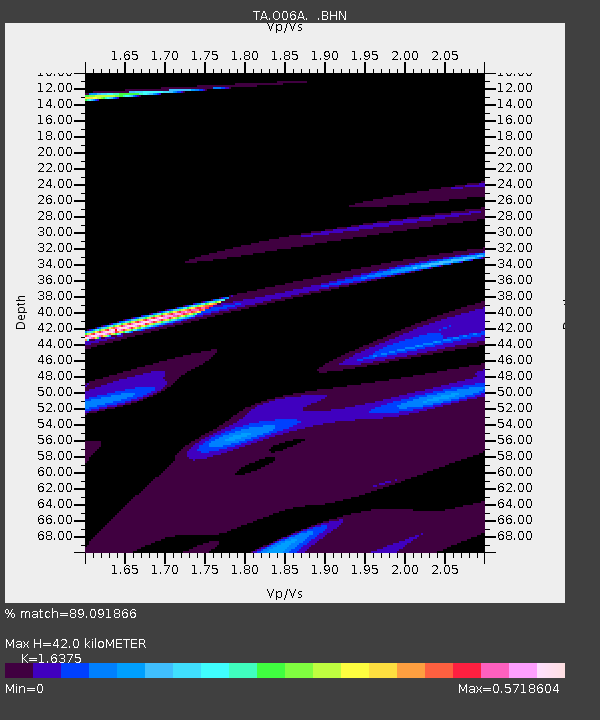
| Estimated Moho Depth: |
42.0 km |
| Estimated Crust Vp/Vs: |
1.64 |
| Assumed Crust Vp: |
6.276 km/s |
| Estimated Crust Vs: |
3.833 km/s |
| Estimated Crust Poisson's Ratio: |
0.20 |
|
| Radial Match: |
89.091866 % |
| Radial Bump: |
400 |
| Transverse Match: |
32.132397 % |
| Transverse Bump: |
400 |
| SOD ConfigId: |
2564 |
| Insert Time: |
2010-03-07 01:14:20.272 +0000 |
| GWidth: |
2.5 |
| Max Bumps: |
400 |
| Tol: |
0.001 |
|
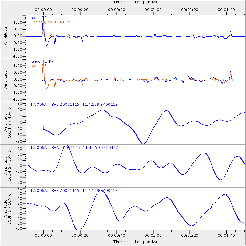
Signal To Noise
| Channel | StoN | STA | LTA |
| TA:O06A: :BHN:20061115T11:42:59.349011Z | 1.0187238 | 2.1258364E-5 | 2.0867643E-5 |
| TA:O06A: :BHE:20061115T11:42:59.349011Z | 0.44916707 | 1.059891E-5 | 2.3596811E-5 |
| TA:O06A: :BHZ:20061115T11:42:59.349011Z | 3.0004225 | 7.817093E-5 | 2.6053309E-5 |
| Arrivals |
| Ps | 4.5 SECOND |
| PpPs | 17 SECOND |
| PsPs/PpSs | 21 SECOND |


