You are here: Home > Network List > UU - University of Utah Regional Network Stations List
> Station MTPU Mt. Pierson, UT, USA > Earthquake Result Viewer
MTPU Mt. Pierson, UT, USA - Earthquake Result Viewer
| Earthquake location: |
Solomon Islands |
| Earthquake latitude/longitude: |
-10.8/161.3 |
| Earthquake time(UTC): |
2016/12/08 (343) 21:56:07 GMT |
| Earthquake Depth: |
15 km |
| Earthquake Magnitude: |
6.5 Mww |
| Earthquake Catalog/Contributor: |
NEIC PDE/us |
|
| Network: |
UU University of Utah Regional Network |
| Station: |
MTPU Mt. Pierson, UT, USA |
| Lat/Lon: |
38.04 N/112.18 W |
| Elevation: |
3112 m |
|
| Distance: |
93.9 deg |
| Az: |
52.176 deg |
| Baz: |
259.37 deg |
| Ray Param: |
0.04117425 |
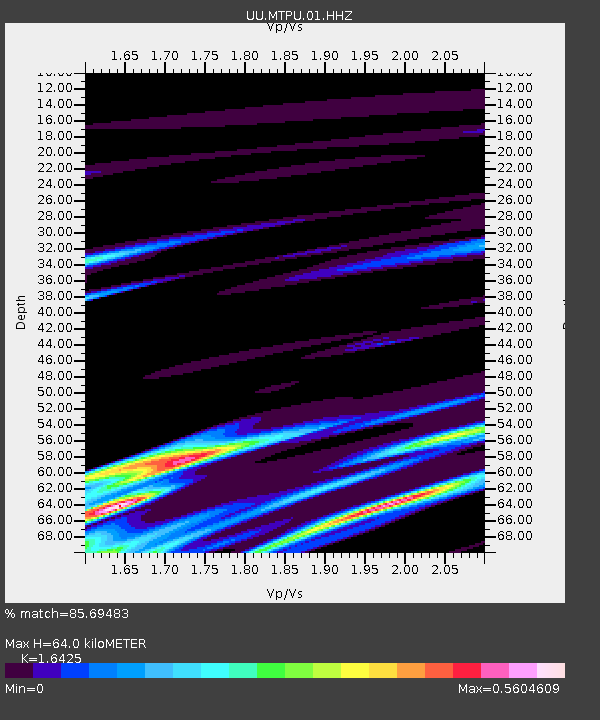
| Estimated Moho Depth: |
64.0 km |
| Estimated Crust Vp/Vs: |
1.64 |
| Assumed Crust Vp: |
6.276 km/s |
| Estimated Crust Vs: |
3.821 km/s |
| Estimated Crust Poisson's Ratio: |
0.21 |
|
| Radial Match: |
85.69483 % |
| Radial Bump: |
337 |
| Transverse Match: |
79.72487 % |
| Transverse Bump: |
358 |
| SOD ConfigId: |
1894071 |
| Insert Time: |
2016-12-22 21:58:03.273 +0000 |
| GWidth: |
2.5 |
| Max Bumps: |
400 |
| Tol: |
0.001 |
|

Signal To Noise
| Channel | StoN | STA | LTA |
| UU:MTPU:01:HHZ:20161208T22:08:52.667996Z | 1.7733191 | 5.011022E-8 | 2.8257869E-8 |
| UU:MTPU:01:HHN:20161208T22:08:52.667996Z | 1.5128893 | 2.6196458E-8 | 1.7315516E-8 |
| UU:MTPU:01:HHE:20161208T22:08:52.667996Z | 1.0852063 | 1.2101869E-8 | 1.1151677E-8 |
| Arrivals |
| Ps | 6.7 SECOND |
| PpPs | 26 SECOND |
| PsPs/PpSs | 33 SECOND |


