You are here: Home > Network List > TA - USArray Transportable Network (new EarthScope stations) Stations List
> Station O06A Flanigan, NV, USA > Earthquake Result Viewer
O06A Flanigan, NV, USA - Earthquake Result Viewer
| Earthquake location: |
Kuril Islands |
| Earthquake latitude/longitude: |
46.6/153.3 |
| Earthquake time(UTC): |
2006/11/15 (319) 11:14:13 GMT |
| Earthquake Depth: |
10 km |
| Earthquake Magnitude: |
6.5 MB, 7.8 MS, 8.3 MW, 7.9 MW |
| Earthquake Catalog/Contributor: |
WHDF/NEIC |
|
| Network: |
TA USArray Transportable Network (new EarthScope stations) |
| Station: |
O06A Flanigan, NV, USA |
| Lat/Lon: |
40.17 N/119.83 W |
| Elevation: |
1229 m |
|
| Distance: |
60.4 deg |
| Az: |
61.637 deg |
| Baz: |
307.638 deg |
| Ray Param: |
0.061550044 |
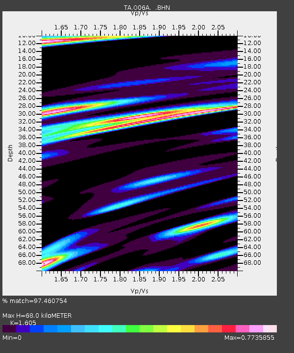
| Estimated Moho Depth: |
68.0 km |
| Estimated Crust Vp/Vs: |
1.61 |
| Assumed Crust Vp: |
6.276 km/s |
| Estimated Crust Vs: |
3.91 km/s |
| Estimated Crust Poisson's Ratio: |
0.18 |
|
| Radial Match: |
97.460754 % |
| Radial Bump: |
400 |
| Transverse Match: |
95.27838 % |
| Transverse Bump: |
400 |
| SOD ConfigId: |
2564 |
| Insert Time: |
2010-03-07 01:14:21.604 +0000 |
| GWidth: |
2.5 |
| Max Bumps: |
400 |
| Tol: |
0.001 |
|
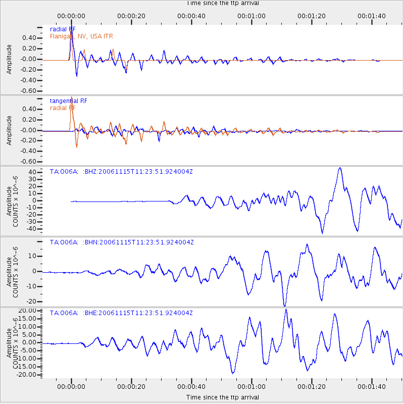
Signal To Noise
| Channel | StoN | STA | LTA |
| TA:O06A: :BHN:20061115T11:23:51.924004Z | 2.0474968 | 3.677649E-7 | 1.7961685E-7 |
| TA:O06A: :BHE:20061115T11:23:51.924004Z | 3.5158713 | 5.8406505E-7 | 1.6612242E-7 |
| TA:O06A: :BHZ:20061115T11:23:51.924004Z | 6.3772964 | 1.4012115E-6 | 2.1971876E-7 |
| Arrivals |
| Ps | 6.9 SECOND |
| PpPs | 27 SECOND |
| PsPs/PpSs | 34 SECOND |


