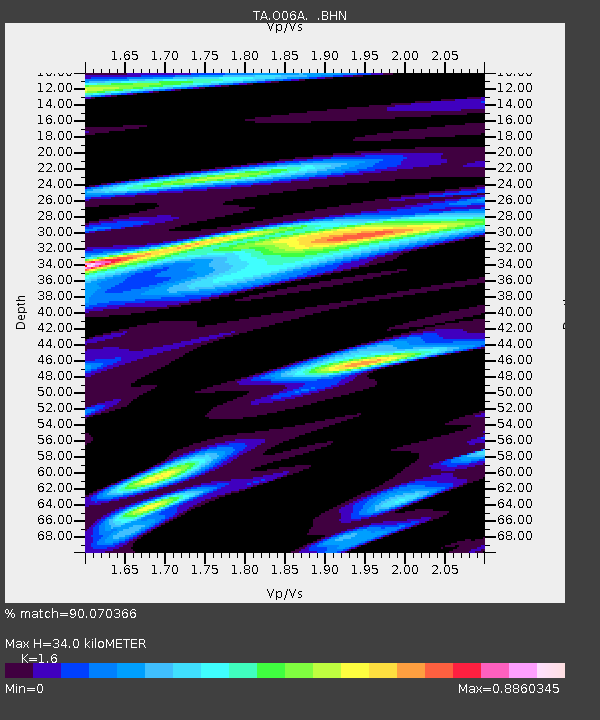
O06A Flanigan, NV, USA - Earthquake Result Viewer
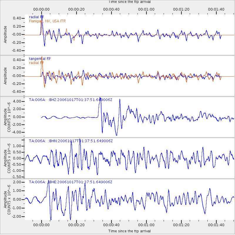
Earthquake location: New Britain Region, P.N.G.
Earthquake latitude/longitude: -5.9/151.0
Earthquake time(UTC): 2006/10/17 (290) 01:25:12 GMT
Earthquake Depth: 32 km
Earthquake Magnitude: 6.4 MB, 6.9 MS, 6.7 MW, 6.6 MW
Earthquake Catalog/Contributor: WHDF/NEIC
Network: TA USArray Transportable Network (new EarthScope stations)
Station: O06A Flanigan, NV, USA
Lat/Lon: 40.17 N/119.83 W
Elevation: 1229 m
Distance: 93.1 deg
Az: 50.12 deg
Baz: 265.0 deg
Ray Param: 0.041310992
Estimated Moho Depth: 34.0 km
Estimated Crust Vp/Vs: 1.60
Assumed Crust Vp: 6.276 km/s
Estimated Crust Vs: 3.922 km/s
Estimated Crust Poisson's Ratio: 0.18
Radial Match: 90.070366 %
Radial Bump: 359
Transverse Match: 84.56984 %
Transverse Bump: 400
SOD ConfigId: 2665
Insert Time: 2010-03-07 01:14:28.618 +0000
GWidth: 2.5
Max Bumps: 400
Tol: 0.001

Signal To Noise

ChannelStoNSTALTA
TA:O06A: :BHN:20061017T01:37:51.649006Z1.41167942.3788434E-71.6851159E-7
TA:O06A: :BHE:20061017T01:37:51.649006Z4.52116359.624393E-72.1287427E-7
TA:O06A: :BHZ:20061017T01:37:51.649006Z13.1331052.32721E-61.7720181E-7
Arrivals
Ps3.3 SECOND
PpPs14 SECOND
PsPs/PpSs17 SECOND