You are here: Home > Network List > TA - USArray Transportable Network (new EarthScope stations) Stations List
> Station O06A Flanigan, NV, USA > Earthquake Result Viewer
O06A Flanigan, NV, USA - Earthquake Result Viewer
| Earthquake location: |
Vanuatu Islands |
| Earthquake latitude/longitude: |
-18.9/169.0 |
| Earthquake time(UTC): |
2006/10/03 (276) 18:03:14 GMT |
| Earthquake Depth: |
171 km |
| Earthquake Magnitude: |
5.9 MB, 6.3 MW, 6.3 MW |
| Earthquake Catalog/Contributor: |
WHDF/NEIC |
|
| Network: |
TA USArray Transportable Network (new EarthScope stations) |
| Station: |
O06A Flanigan, NV, USA |
| Lat/Lon: |
40.17 N/119.83 W |
| Elevation: |
1229 m |
|
| Distance: |
88.4 deg |
| Az: |
46.517 deg |
| Baz: |
243.713 deg |
| Ray Param: |
0.042216312 |
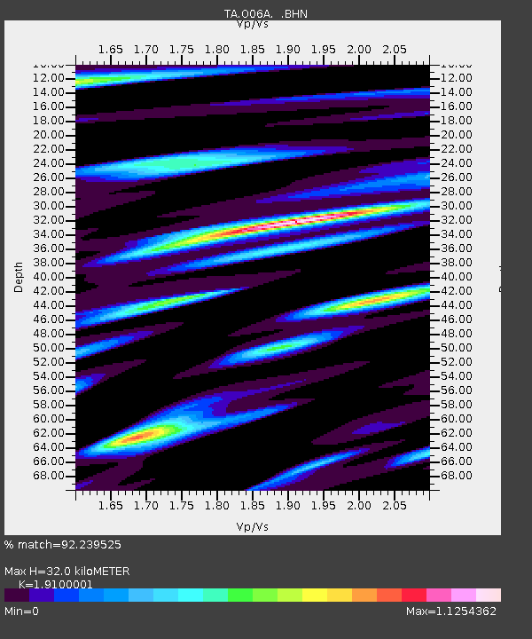
| Estimated Moho Depth: |
32.0 km |
| Estimated Crust Vp/Vs: |
1.91 |
| Assumed Crust Vp: |
6.276 km/s |
| Estimated Crust Vs: |
3.286 km/s |
| Estimated Crust Poisson's Ratio: |
0.31 |
|
| Radial Match: |
92.239525 % |
| Radial Bump: |
400 |
| Transverse Match: |
87.405525 % |
| Transverse Bump: |
400 |
| SOD ConfigId: |
2665 |
| Insert Time: |
2010-03-07 01:14:33.997 +0000 |
| GWidth: |
2.5 |
| Max Bumps: |
400 |
| Tol: |
0.001 |
|
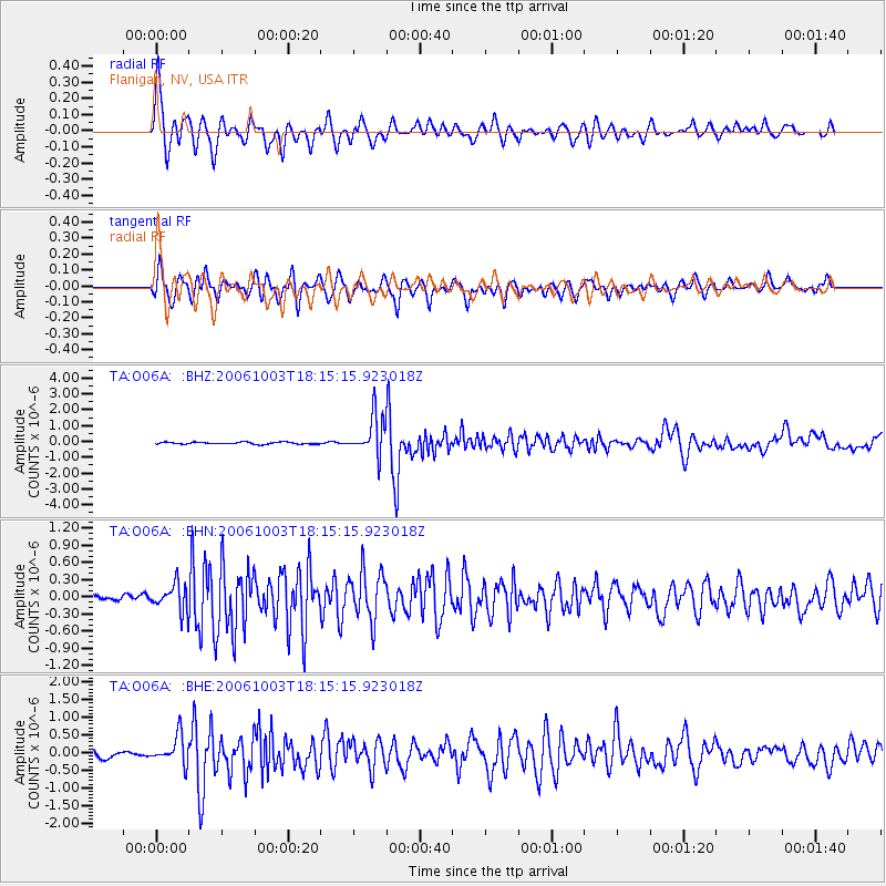
Signal To Noise
| Channel | StoN | STA | LTA |
| TA:O06A: :BHN:20061003T18:15:15.923018Z | 6.072938 | 2.321532E-7 | 3.8227494E-8 |
| TA:O06A: :BHE:20061003T18:15:15.923018Z | 4.3620906 | 4.0182707E-7 | 9.211799E-8 |
| TA:O06A: :BHZ:20061003T18:15:15.923018Z | 19.306887 | 1.2295716E-6 | 6.368565E-8 |
| Arrivals |
| Ps | 4.7 SECOND |
| PpPs | 15 SECOND |
| PsPs/PpSs | 19 SECOND |


